Book of Mormon Geography

The upper-crust forum for scholarly, polite, and respectful discussions only. Heavily moderated. Rated G.
User avatar
Zosimus
Star B
Posts: 106
Joined: Tue Aug 16, 2022 4:10 pm

Re: Book of Mormon Geography

Post by Zosimus »

Moksha wrote:
Sat Oct 08, 2022 1:52 pm
This premise would be based on Joseph having a truly phenomenal memory and the forethought to extend this story in remarkable ways. How were the golden plates of the Malay Penisula conveyed to Upper New York State?
As you know, popular folklore had it that Captain Kidd had hid the booty from the Kedah Merchant along the New England coast and even into upper New York State. Luman Walters. Porter Rockwell, Martin Harris, the Smiths and a number of others were seeking the buried loot from the Kedah Merchant. in my opinion, the golden plates were part of the larger stash of the Kedah Merchant booty. Joseph claimed to know where this loot was buried through visions of the Kedah Merchant sailing up the Susquehanna and after using his peepstone (the same stone he used to translate the golden plates) to translate etchings in an unknown language he found cut in rocks.

Kedah was the main port on the Malay Peninsula and was said to be founded by a warrior from the Middle East named (and this is extremely important since its highly unlikely to be a simple coincidence) Maroni. (source)

Image

It's my opinion that Luman Walters and the Smiths named the guardian of the Kedah treasure -- including the golden plates -- Maroni, after the founder of Kedah, Malaysia. What better name for the guardian of the Kedah Merchant treasure buried in Cumorah then the founder of Kedah, known by Arab geographers as Comoro?

In his 1832 autobiography, Joseph spelled Moroni as Maroni. The angel was named Maroni (not Moroni) in later drafts as late as 1841.
User avatar
Moksha
God
Posts: 5928
Joined: Wed Oct 28, 2020 3:13 am
Location: Koloburbia

Re: Book of Mormon Geography

Post by Moksha »

Zosimus wrote:
Sun Oct 09, 2022 4:23 am
In his 1832 autobiography, Joseph spelled Moroni as Maroni. The angel was named Maroni (not Moroni) in later drafts as late as 1841.
So this story later became babelfied by subsequent Latter-day Saints and apologists into some nonsense about Mesoamerica?
Cry Heaven and let loose the Penguins of Peace
User avatar
Shulem
God
Posts: 7090
Joined: Wed Oct 28, 2020 1:40 am
Location: Facsimile No. 3

Re: Book of Mormon Geography

Post by Shulem »

Zosimus wrote:
Sun Oct 09, 2022 4:23 am
In his 1832 autobiography, Joseph spelled Moroni as Maroni. The angel was named Maroni (not Moroni) in later drafts as late as 1841.

<Cough>

Well, yes and no or not exactly.

The 1832 original autobiography was penned by multiple scribes including Joseph Smith who recorded the bit about his First Vision. But Fredrick G. Williams was the scribe (penman) who wrote “Maroni & his fathers” .

Two additional copies of the account were both penned by Howard Coray in 1841, one of which he retained Williams’s original spelling but in the other he corrected it while copying and crossed out “Maroni” and then wrote “Moroni”:

1. “Maroni whom I have sent unto you to reveal the Book of Mormon”
2. Maroni Moroni whom I have sent unto you to reveal the Book of Mormon”
User avatar
Shulem
God
Posts: 7090
Joined: Wed Oct 28, 2020 1:40 am
Location: Facsimile No. 3

Re: Book of Mormon Geography

Post by Shulem »

Zosimus wrote:
Sat Oct 08, 2022 9:40 am
So in short, my opinion is that Joseph Smith was not borrowing the name Cumorah from the Comoros Islands, he was borrowing it from the peninsula known to Arabs as Comoro, the native land of the treasure guardian of Captain Kidd’s Kedah Merchant, Maroni.

That is entirely plausible.

Zosimus wrote:
Sun Oct 09, 2022 4:23 am
It's my opinion that Luman Walters and the Smiths named the guardian of the Kedah treasure -- including the golden plates -- Maroni, after the founder of Kedah, Malaysia. What better name for the guardian of the Kedah Merchant treasure buried in Cumorah then the founder of Kedah, known by Arab geographers as Comoro?

Again, that is plausible.

Now with that said, we have no way of knowing how Walters may have pronounced the name “Maroni” or how Smith may have perceived (heard) it. All that is conjecture. But based on the fact that Fredrick G. Williams recorded “Maroni” in the autobiography via Smith’s dictation, it’s quite reasonable to assume that “Maroni” is how Joseph pronounced the name. Spelling now becomes the issue.

For the record, the Printer’s Manuscript in the handwriting of Oliver Cowdery is as follows: “Now I Moroni write somewhat as seemeth me good”.

So, there you have it.
User avatar
Shulem
God
Posts: 7090
Joined: Wed Oct 28, 2020 1:40 am
Location: Facsimile No. 3

Re: Book of Mormon Geography

Post by Shulem »

Moksha wrote:
Sat Oct 08, 2022 6:19 am
If we went with the hypothesis that the Malay Peninsula was the setting of the Book of Mormon

For the record, here is that link: THE MALAY PENINSULA as the setting For the Book of Mormon
User avatar
Shulem
God
Posts: 7090
Joined: Wed Oct 28, 2020 1:40 am
Location: Facsimile No. 3

Re: River Sidon at Delmarva

Post by Shulem »

Shulem wrote:
Sun Oct 09, 2022 12:50 am
So, in which direction did the water flow?
Alma 22 wrote:27 And it came to pass that the king sent a proclamation throughout all the land, amongst all his people who were in all his land, who were in all the regions round about, which was bordering even to the sea, on the east and on the west, and which was divided from the land of Zarahemla by a narrow strip of wilderness, which ran from the sea east even to the sea west, and round about on the borders of the seashore, and the borders of the wilderness which was on the north by the land of Zarahemla, through the borders of Manti, by the head of the river Sidon, running from the east towards the west—and thus were the Lamanites and the Nephites divided.

28 Now, the more idle part of the Lamanites lived in the wilderness, and dwelt in tents; and they were spread through the wilderness on the west, in the land of Nephi; yea, and also on the west of the land of Zarahemla, in the borders by the seashore, and on the west in the land of Nephi, in the place of their fathers’ first inheritance, and thus bordering along by the seashore.

29 And also there were many Lamanites on the east by the seashore, whither the Nephites had driven them. And thus the Nephites were nearly surrounded by the Lamanites; nevertheless the Nephites had taken possession of all the northern parts of the land bordering on the wilderness, at the head of the river Sidon, from the east to the west, round about on the wilderness side; on the north, even until they came to the land which they called Bountiful.

To be fair, it could be argued that the phrase “from the east to the west” typifies the expression of how light of the rising sun shines to cover the area of all earth from the east to the west; the 1835 Hymn book references part of that expression:

Hymn 31, verse 3 wrote:We can then live in peace,
With a joy on the mountains,
As the earth doth increase,
With a joy by the fountains,
For the world will be blest,
With a joy to rely on,
From the east to the west,
Through the glory of Zion.

The phrase is also found in Joseph Smith, Sr.’s vision of the Tree of Life (1811) which references a stream of water as recorded in Lucy Mack Smith’s history:

Joseph Smith Sr. wrote:Traveling a short distance further, I came to a narrow path. This path I entered, and, when I had traveled a little way in it, I beheld a beautiful stream of water which ran from the east to the west. Of this stream I could see neither the source nor yet the mouth, but as far as my eyes could extend I could see a rope, running along the bank of it about as high as a man could reach, and beyond me was a low but very pleasant valley in which stood a tree such as I had never seen before.

Thus, it could be construed that the phrase is simply a generic expression that can be applied to just about anything. But what of the case of the river Sidon in the Book of Mormon? Interestingly enough, there is an example in the Book of Mormon when *opposite* directions are used in a generic way:

3 Nephi 1 wrote:17 And they began to know that the Son of God must shortly appear; yea, in fine, all the people upon the face of the whole earth from the west to the east, both in the land north and in the land south, were so exceedingly astonished that they fell to the earth.

But even more important, we are given a specific reference by certain brethren including the prophet’s brother (Don Carlos) who visited London England and noted how the River Thames flows from “west to east” which in fact is the very direction in which the Thames flows.

Church History 28 October 1840 Wednesday wrote:Houses of Parliament, Buckingham Palace &c. South lies the River Thames running from west to east, with five large arched bridges across it

Therefore, it seems fair enough to conclude that the references given of the river Sidon (“east to the west”) refer to the direction of water flow and is not a generic expression of area. The example of the River Thames given by the brethren who went to England provides proof that the interpretation of water flow (“west to the east”) is spot on!

This new interpretation (which is correct) is very bad news for the apologists.
User avatar
Shulem
God
Posts: 7090
Joined: Wed Oct 28, 2020 1:40 am
Location: Facsimile No. 3

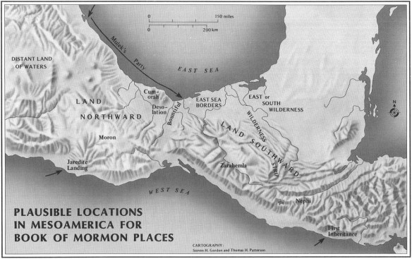
Question for Brant Gardner

Post by Shulem »

Brant Gardner wrote:Image
Image

Brant,

Will you please show me on your map the location of the river Sidon which runs “from the east towards the west” and therefore flows into the west sea?

Thanks,

Shulem
User avatar
Zosimus
Star B
Posts: 106
Joined: Tue Aug 16, 2022 4:10 pm

Re: Book of Mormon Geography

Post by Zosimus »

Moksha wrote:
Sun Oct 09, 2022 9:46 am
So this story later became babelfied by subsequent Latter-day Saints and apologists into some nonsense about Mesoamerica?
The Americanization of the narrative started somewhere between Martin Harris as scribe and Oliver Cowdery as scribe. My take is that when Samuel Mitchell had told Martin Harris that the reformed egyptian characters on the transcript were of a nation now extinct in the east, he identified that nation as Malay or Australasian. I won't offer a detailed explanation here because Richard Bennet explains better than I could here.

So let's say Samuel Mitchell had told Martin Harris that the "nation now extinct" was Malay, or what we call today Polynesian. This is where things get interesting.

Remember how the earliest accounts of Book of Mormon geography claim that the Lehites landed "a little south of the Isthmus of Darien"? Lo behold, an account given by Samuel Mitchell as supporting evidence of his theory that the Indians of New York State were Malay:

“Soon after the arrival of these rolls from New Spain, filled with hieroglyphic and imitative characters, I received a visit from three natives of South America, born at St. Blas, just beyond the Isthmus of Darien, on the eastern side, between Portobello and Carthagena…They were of the Malay race, by their physiognomy, form and general appearance.” - Samuel Mitchill

Its possible that Samuel Mitchell had mentioned these natives from the Isthmus of Darien as he explained his theory of Polynesian Native Americans to Martin Harris, and if not, it had been published in 1820 and was available to anyone curious about the current theories of Native American origins.

I propose that Martin Harris, Joseph Smith and other early Saints were aware of Mitchell's theories about Native American origins and his suggestion that there had been a great final battle of extinction in Onandaga County, only around 40 miles from the Hill Cumorah. The early Saints were adjusting the narrative to account for Nephites and Lamanites as new evidence emerged. For example, Orson Pratt continued to riff on Mitchell's theory in 1840 (source):

"A great and terrible war commenced between them, which lasted for many years, and resulted in the complete overthrow and destruction of the Nephites. This war commenced at the Isthmus of Darien, and was very destructive to both nations for many years. At length, the Nephites were driven before their enemies, a great distance to the north, and north-east; and having gathered their whole nation together, both men, women, and children, they encamped on, and round about the hill Cumorah, where the records were found, which is in the State of New York."

I suppose the thinking was, if the narrative was aligned as close as possible to the leading theories of the day, it would be more believable. This explains why Joseph appears to totally fumble the Zelph story by introducing characters that don't even appear in the Book of Mormon. The account of Zelph the White Lamanite fighting for the Prophet Onandagus was not intended as a way to align the evidence with the Book of Mormon but rather a way to align the Book of Mormon storyline with Mitchell's theory that fair skinned tartars had driven the Malay to extinction in Onandaga County.
User avatar
Zosimus
Star B
Posts: 106
Joined: Tue Aug 16, 2022 4:10 pm

Re: River Sidon at Delmarva

Post by Zosimus »

Shulem wrote:
Sun Oct 09, 2022 10:11 pm
Therefore, it seems fair enough to conclude that the references given of the river Sidon (“east to the west”) refer to the direction of water flow and is not a generic expression of area. The example of the River Thames given by the brethren who went to England provides proof that the interpretation of water flow (“west to the east”) is spot on!

This new interpretation (which is correct) is very bad news for the apologists.
Agree, the text is clear that the Sidon headwaters at Manti ran from east to west. The only geography model that gets Sidon and all of the Land of Zarahemla right is Malay.

Image

My ace card is how the ancient real world highways and mountain passes of the Malay Peninsula line up perfectly with the highways and mountain passes described in the Book of Mormon. There is a mountain pass between the west sea and Ammonihah, a mountain pass between Gideon and Gid as well as a mountain pass between Manti and Nephihah. The Line Bountiful is an ancient highway connecting the ancient port cities of Kra on the west sea and Chumphon on the east sea. Most importantly the Bandon River has its headwaters in the east in a narrow strip of wilderness and runs west until it curves north past the ancient capital city of Sra in the center of the peninsula.

Image

No other model comes close to the level of detail and alignment the Malay geography has with the internal geography of the Book of Mormon.
User avatar
Zosimus
Star B
Posts: 106
Joined: Tue Aug 16, 2022 4:10 pm

Re: Book of Mormon Geography

Post by Zosimus »

Shulem wrote:
Sun Oct 09, 2022 4:01 pm
For the record, here is that link: THE MALAY PENINSULA as the setting For the Book of Mormon
This is Ralph Olsen’s model, the first to propose the Malay Peninsula. The model I propose is set farther north in the area that was known as Kamara or Komoriyya during the Book of Mormon timeframe. I live in the region and have carefully studied the historical texts and have personally visited nearly every proposed point to assure that distances and geographical features line up with the internal geography.
Post Reply