Shulem wrote: ↑Wed Sep 13, 2023 12:09 pm
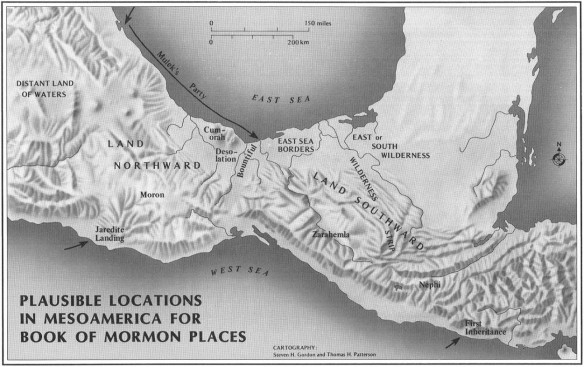
Apologists have correctly reasoned (by the text) that Sidon originates its headwaters in the interior of the land -- in the middle of the peninsula beginning at Manti. Yes, Manti is the source of the river Sidon and the area
round about that source is the land of Manti. Everything that flows away from Manti is the watery current that finds its way to the sea.
The river Sidon is never mentioned anywhere NORTH of Manti.
So, if you guessed that Sidon is the
Ace of Hearts, you guessed correct.
This thread has already covered a lot of material about Manti and the river Sidon. But a closer look and more in depth look is now justified in order to validate my claims.
Shulem wrote: ↑Wed Sep 21, 2022 1:35 pm
In time, at the right moment, I’ll play the
Ace of Hearts. That card will really get your attention and make the apologists shake in their boots. I’ll keep that card up my sleeve until it’s time to play it -- along side the King, Queen, and Jack of Hearts.
Yeah baby! Shulem has the winning cards.

Doctor CamNC4Me wrote: ↑Mon Sep 11, 2023 11:11 pm
I await your masterstroke with baited breath, mon ami.
- Doc
KEY WORD = “Running”
1 Nephi 2:9 wrote:And when my father saw that the waters of the river emptied into the fountain of the Red Sea, he spake unto Laman, saying: O that thou mightest be like unto this river, continually running into the fountain of all righteousness!
A. Fresh source water
B. River
C. Flow/current
D. Outlet
E. Sea
*Note that the direction of flow corresponds with direction but a river has many turns and twists and so the overall general direction of flow is based on the long term run of the river in comparison to the source and the outlet that leads into the sea. For example: The mighty Mississippi flows from north to south.
Alma 22:27 wrote:And it came to pass that the king sent a proclamation throughout all the land, amongst all his people who were in all his land, who were in all the regions round about, which was bordering even to the sea, on the east and on the west, and which was divided from the land of Zarahemla by a narrow strip of wilderness, which ran from the sea east even to the sea west, and round about on the borders of the seashore, and the borders of the wilderness which was on the north by the land of Zarahemla, through the borders of Manti, by the head of the river Sidon, RUNNING from the east towards the west—and thus were the Lamanites and the Nephites divided.
A. The
regions of land are flanked by both east and west seas respectively
B. The
regions of land are bordered by
sea east and
sea west
C. Land of Zarahemla is
divided from sea east and sea west by a
narrow strip of wilderness
D. The narrow strip of wilderness runs north and south being flanked by the seas
E. The narrow strip of wilderness is round about on the borders of the seashore
F. The narrow strip of wilderness leads all the way to Manti which was the head of the river Sidon
G. The narrow strip of wilderness extends to the
north of Zarahemla through Manti and Zarahemla which is divided by the river
E. The Nephites and Lamanites are divided by the river Sidon that runs in-between the east and west seas
F. The
RUNNING current of river Sidon flows
FROM THE EAST TOWARDS THE WEST SEA and the river divides the Nephites from the Lamanites!
Alma 50:11 wrote:And thus he cut off all the strongholds of the Lamanites in the east wilderness, yea, and also on the west, fortifying the line between the Nephites and the Lamanites, between the land of Zarahemla and the land of Nephi, from the west sea, running by the head of the river Sidon—the Nephites possessing all the land northward, yea, even all the land which was northward of the land Bountiful, according to their pleasure