What’s New
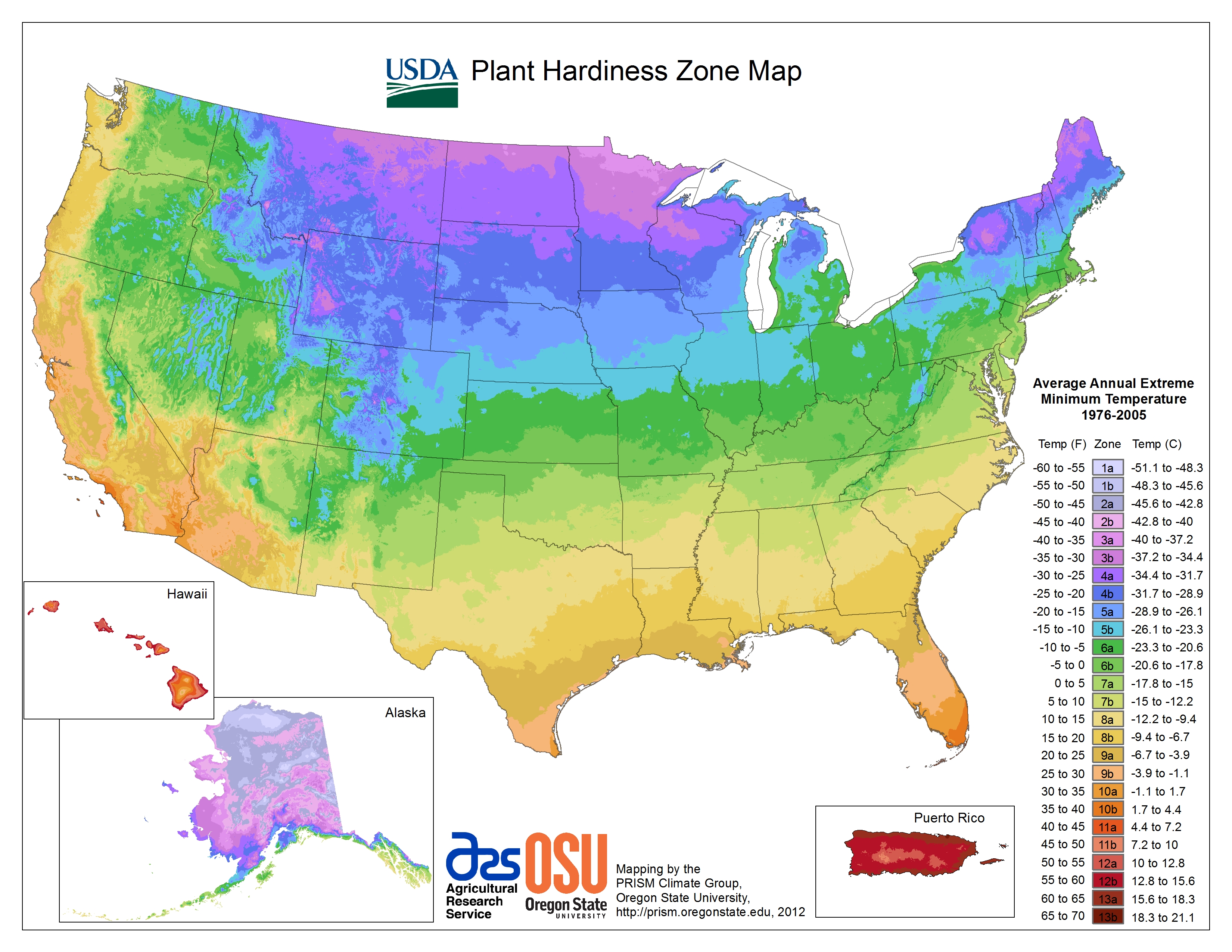
This edition of the USDA Plant Hardiness Zone Map (PHZM) is GIS (Geographic Information System)-based and is specifically designed for the Internet. It enables viewers to examine plant hardiness zones at a much finer scale than 1990 and earlier maps. A very sophisticated algorithm was used to interpolate low-temperature values between actual weather reporting stations. A personal ZIP Code zone finder is also included with this version of the map. Simply type your ZIP Code in the proper box and your zone will be reported.
New Data
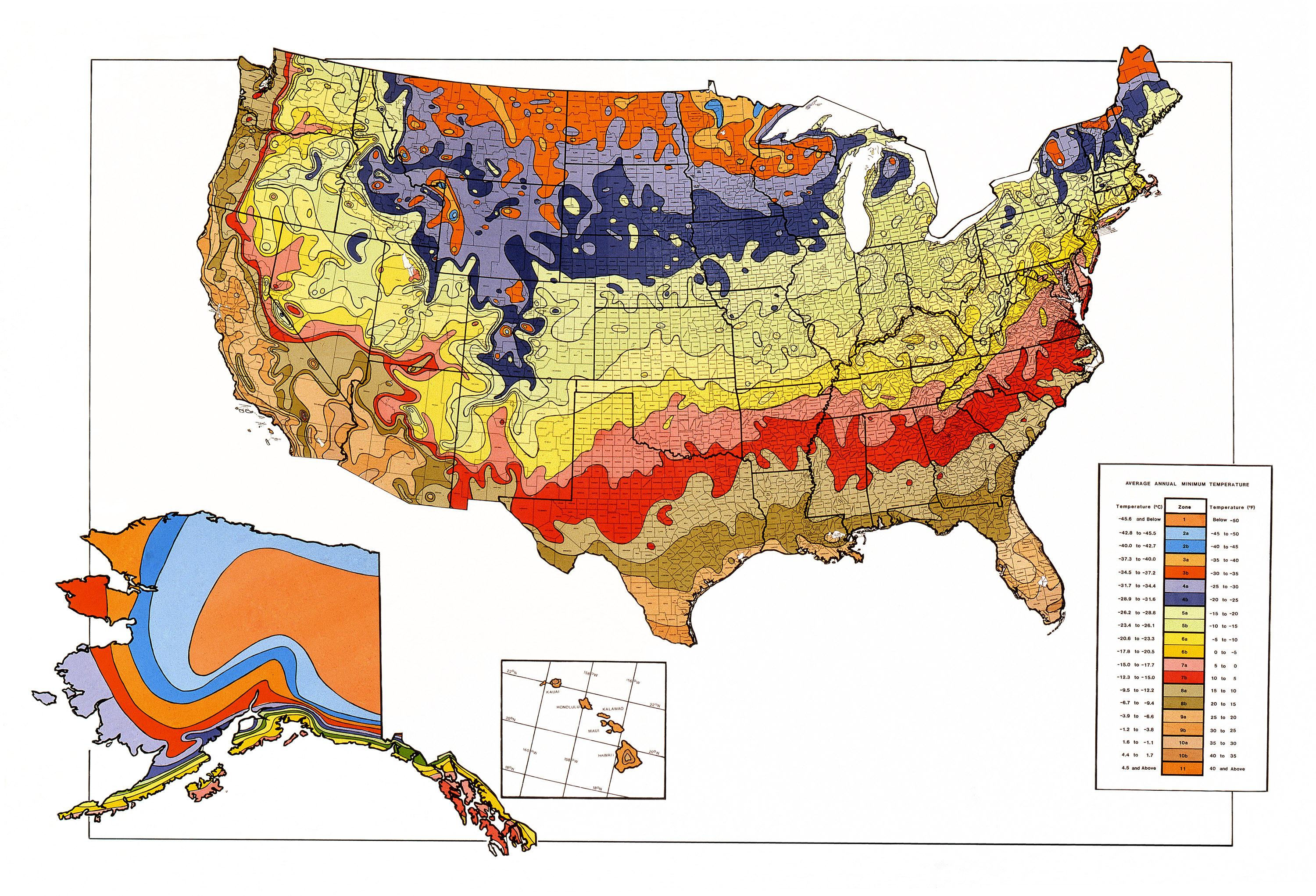
The edition of the USDA PHZM revised and published in 1990 was drawn from weather data from 1974–1986. The longer period (30 years) of data in the 2012 and this 2023 version of the USDA PHZM was selected by the group of horticultural, botanical, and climatological experts who led the review of the latest revision as the best balance between smoothing out the fluctuations of year-to-year weather variation and the concept that, during their lifetimes, perennial plants mostly experience what is termed "weather" rather than "climate." The 1991-2020 period also aligns with the period currently in use by climatologists to describe baseline climate “normals” in the U.S.
New Zones
Two new zones were added to 2012 and this 2023 edition of the USDA PHZM. Zones 12 and 13 have been introduced for regions with average annual extreme minimum temperatures above 50 degrees and 60 degrees F, respectively. They appear only on the maps for Hawaii and Puerto Rico. Nonetheless, the additional frost-free zones will enable better definition of conditions for tropical and semitropical plants, which often serve as house or patio plants in many parts of the country. The two new zones will provide a way to share information about differences in cold sensitivity of tropical ornamental plants and could help gardeners decide when to bring tropical plants indoors from a deck or patio as the temperature cools.
Finer Scale
Because the 2023 and 2012 maps were created digitally with GIS technology, they have a higher level of resolution and can show smaller areas of zone delineations than earlier maps. For example, cities tend to hold more heat because they encompass large areas of concrete and blacktop, so a city or town might be assigned to a zone warmer than the surrounding countryside. Higher elevations tend to be colder than surrounding lower areas, so the top of a mountain might be an area of cooler zones. A location near a large body of unfrozen water, especially downwind from prevailing breeze from that water, might provide milder winter weather and be in a warmer zone.
Climate Change
Climate changes are usually based on trends in overall annual average temperatures recorded over 50-100 years. Because the USDA PHZM represents 30-year averages of what are essentially extreme weather events (the coldest temperature of the year), changes in zones are not reliable evidence of whether there has been global warming.
Compared to the 2012 and 1990 maps, zone boundaries in this 2023 edition have shifted in many areas. The new PHZM is generally about one quarter-zone warmer than reported in the 2012 PHZM throughout much of the United States, as a result of a more recent averaging period (1976-2005 vs. 1991-2020). However, some of the changes in the zones are the results of additional data sources and improved interpolation methods. These zone shifts can sometimes result in a cooler, rather than warmer, zone. The most substantial changes produced by additional data sources and improved interpolation methods are seen in upland areas of Alaska.
Canada and Mexico
The 1990 PHZM included Canada and Mexico for the first time. In the 2012 and 2023 versions, the latest mapping technology was focused on creating the highest-quality PHZM for the United States, including Puerto Rico. Canada has developed its own plant hardiness zone map, which can be accessed here
http://planthardiness.gc.ca/ (Mexico does not yet have a similar map).
Mapmaking
A complex algorithm was used for this edition of the PHZM to enable more accurate interpolation between weather reporting stations. This method accounts for factors such as elevation changes and proximity to bodies of water, which enabled mapping of more accurate zones.
Temperature station data for this 2023 edition of the USDA PHZM came from many different sources. In the eastern and central United States, Puerto Rico, and Hawaii, data came primarily from weather stations of the National Weather Service and several state networks. In the western United States and Alaska, data from stations maintained by USDA Natural Resources Conservation Service, USDA Forest Service, U.S. Department of the Interior (DOI) Bureau of Reclamation, and DOI Bureau of Land Management also helped to better define hardiness zones in mountainous areas. Environment Canada provided data from Canadian stations, and data from Mexican stations came from the Mexico National Weather Service and the Global Historical Climate Network. The Alaska PHZM also benefitted from the use of high-elevation modeled data from the National Centers for Environmental Prediction’s (NCEP’s) North American Regional Reanalysis (NARR). In addition, high-elevation temperature estimates in the conterminous U.S. were improved with the use of the National Center for Atmospheric Research (NCAR)/NCEP global Reanalysis 1 dataset.
All data were carefully examined to ensure that only the most reliable were used in the mapping. In the end, data from a total of 13,625 stations—a substantial increase compared to the 2012 map version--were incorporated into the maps. The USDA PHZM was produced with the latest version of PRISM, a highly sophisticated climate mapping technology developed at Oregon State University. The map was produced from a digital computer grid, with each cell measuring about a half mile on a side. PRISM estimated the mean annual extreme minimum temperature for each grid cell (or pixel on the map) by examining data from nearby stations; determining how the temperature changed with elevation; and accounting for possible coastal effects, temperature inversions, and the type of topography (ridge top, hill slope, or valley bottom).
Information on PRISM can be obtained from the PRISM Climate Group website
https://prism.oregonstate.edu
Once a draft of the map was completed, it was reviewed by a team of climatologists, agricultural meteorologists, and horticultural experts. If the zone for an area appeared anomalous to these expert reviewers, experts doublechecked the draft maps for errors or biases.
A detailed explanation of the mapmaking process and a discussion of the horticultural applications of the 2012 PHZM are available from the articles listed below. Any additional articles will be added to this list as they are published.
Daly, C., M.P. Widrlechner, M.D. Halbleib, J.I. Smith, and W.P. Gibson. 2012. Development of a new USDA Plant Hardiness Zone Map for the United States. Journal of Applied Meteorology and Climatology, 51: 242-264.
Widrlechner, M.P., C. Daly, M. Keller, and K. Kaplan. 2012. Horticultural Applications of a Newly Revised USDA Plant Hardiness Zone Map. HortTechnology, 22: 6-19.
Acknowledgement and Citation
The USDA Agricultural Research Service thanks all of the many people who helped produce the newest edition of the USDA Plant Hardiness Zone Map (PHZM), especially the members of the PHZM Technical Review Team.
Special thanks are due to the director and staff of the PRISM Climate Group, Oregon State University, Corvallis, OR, for their tireless and generous services in the creation of the new map.
Suggested Citation
Please use the following reference when citing the Plant Hardiness Zone Map (PHZM) on this website:
USDA Plant Hardiness Zone Map, 2023. Agricultural Research Service, U.S. Department of Agriculture. Accessed from
https://planthardiness.ars.usda.gov/


