
After Nephi and his brethren returned to Lehi’s tent with the brass plates, we are informed that Lehi “did offer sacrifice and burnt offerings unto the Lord.” Bear in mind that the trip back from Jerusalem is estimated to be about 274 miles. That’s at least a couple of weeks of daily travel. Did they bring livestock back with them to perform the “burnt offerings” or were animal(s) miraculously provided for the offerings from the surroundings in which they dwelt? Bear in mind that burnt offerings are wholly burned and not consumed or eaten according to the Levitical law prescribed by Moses. What a waste of good meat! Although the text opens the possibility that there were multiple kinds of offerings, “sacrifice” and “burnt”, it remains to be seen how Lehi would have performed rites of sacrifice because the skimpy narrative provides no explanation on how the necessary animals required to perform animal sacrifice were obtained. Smith is just telling his story on the fly; making it all up out of thin air!
It’s all fiction.
Book of Mormon Geography
-
huckelberry
- God
- Posts: 2648
- Joined: Wed Oct 28, 2020 3:48 pm
Re: Book of Mormon Geography
Not to argue, but perhaps to avoid being too easy I considered this Saudi Arabia thing again. OK I enjoy google map areal photo. It is hard to see how people live in that country. Rocks and sand and sand yet people have been living there for millennia.
In the area we are looking at there is a north south highway some 15 miles inland. It follows a network of sand paths which would be a likely travel route anytime in the past. So the southward journey would be possible. there are feeder sand paths to the wadi in question so those could be followed to access this particular occasional trickle of water. So Shulem your original observation about river may be the best point.
I also noted from wikapedia that there was game in the area in the past, extensively hunted in 19th century almost eliminating them at that time.
Re: Book of Mormon Geography
Huck,huckelberry wrote: ↑Mon Oct 09, 2023 5:30 pmIn the area we are looking at there is a north south highway some 15 miles inland. It follows a network of sand paths which would be a likely travel route anytime in the past. So the southward journey would be possible.
An inland journey away from the Red Sea on the other side of the mountains does not fit the definitions described by the text. The apologists came up with that idea in looking for their river and valley but Lehi is said to have skirted the coast of the Red Sea the entire time while traveling south for three days. Here is how the narrative reads:
1 Nephi 2 wrote:4 And it came to pass that he departed into the wilderness. And he left his house, and the land of his inheritance, and his gold, and his silver, and his precious things, and took nothing with him, save it were his family, and provisions, and tents, and departed into the wilderness.
5 And he came down by the borders near the shore of the Red Sea; and he traveled in the wilderness in the borders which are nearer the Red Sea; and he did travel in the wilderness with his family, which consisted of my mother, Sariah, and my elder brothers, who were Laman, Lemuel, and Sam.
6 And it came to pass that when he had traveled three days in the wilderness, he pitched his tent in a valley by the side of a river of water.
7 And it came to pass that he built an altar of stones, and made an offering unto the Lord, and gave thanks unto the Lord our God.
8 And it came to pass that he called the name of the river, Laman, and it emptied into the Red Sea; and the valley was in the borders near the mouth thereof.
9 And when my father saw that the waters of the river emptied into the fountain of the Red Sea, he spake unto Laman, saying: O that thou mightest be like unto this river, continually running into the fountain of all righteousness!
10 And he also spake unto Lemuel: O that thou mightest be like unto this valley, firm and steadfast, and immovable in keeping the commandments of the Lord!
First, they came down by the borders near the shore of the Red Sea which is the northern area of the gulf of Aqaba. The point is they reached the Red Sea and are “near the shore.” Then we learn they travelled three days in the wilderness on the same course which maintains the shore of the Red Sea. The point is they traveled in the wilderness in the borders which are nearer the Red Sea! After this juncture the river Laman is spotted and is seen emptying into the Red Sea. Therefore, they must be on the shoreline! We are informed that the valley in which they resided was in the borders near the mouth that fed the sea -- or in other words they were close to the shoreline and were said to describe the river emptying into the sea. That is when Lehi SAW the river emptied into the fountain of the Red Sea and likened Lemuel as a valley along the mountainous coast in which they stood.
Later in 16:12, Nephi says, “we did take our tents and depart into the wilderness, across the river Laman.” And from there they continue to maintain the same course they had already taken since first arriving at the borders of the Red Sea at the northernmost point and continued to head southward along the Red Sea coast:
1 Nephi 16 wrote:13 And it came to pass that we traveled for the space of four days, nearly a south-southeast direction, and we did pitch our tents again; and we did call the name of the place Shazer.
14 And it came to pass that we did take our bows and our arrows, and go forth into the wilderness to slay food for our families; and after we had slain food for our families we did return again to our families in the wilderness, to the place of Shazer. And we did go forth again in the wilderness, following the same direction, keeping in the most fertile parts of the wilderness, which were in the borders near the Red Sea.
Re: Book of Mormon Geography
huckelberry wrote: ↑Mon Oct 09, 2023 5:30 pmNot to argue, but perhaps to avoid being too easy I considered this Saudi Arabia thing again.
Huck,
I appreciate you being here. And, before long, I will blow the lid off Arabia and put an end to silly Mormon apologetics with regard to the Red Sea and Lehi’s trek in fleeing there from Jerusalem. I think the time has come. Are you ready?
Book of Mormon geography starts at Jerusalem and leads to the Red Sea. Trust Shulem to get the job done. This is going to be juicy good.
PS. I just love how Joseph Smith worked his story out! Such marvelous fiction!

Re: Book of Mormon Geography
Excellent point. If they had a more plausible story like Huck and Tom floating down a river on a raft of curious construction, they would shout it from the rooftops instead of worrying about people uncovering the shoddiness of their proposed evidence.
Cry Heaven and let loose the Penguins of Peace
-
huckelberry
- God
- Posts: 2648
- Joined: Wed Oct 28, 2020 3:48 pm
Re: Book of Mormon Geography
Well, I may be a fictional character but the river is real and my guide. Mr. Twain knew the real river and what kind of stuff happened around it (with a few stretchers).
Re: Red Sea
Joseph Smith did not have Google earth nor did he have the luxury of modern maps we have today. Maps, atlases, and globes available to Smith were from his era or before, some of which were no doubt of vintage date. Certainly, he was familiar with biblical maps and his education in geography was subject to what was available to him.
A Map of the Sacred Geography Taken From the Old and New Testament. Containing Most of Ye Then Known Parts of the World and By Whom Peopled.
Published by John Senex in London around 1716 (Look at those rivers in Arabia!)
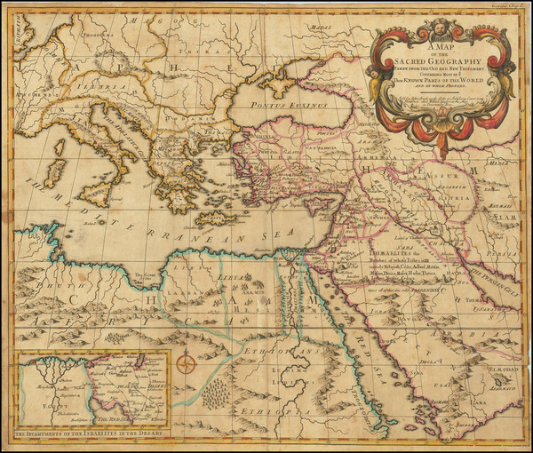
So, the first leg of the journey through Arabia is from Jerusalem “down by the borders near the shore of the Red Sea.” Lehi fled Jerusalem and took his family consisting of his wife, sons, and daughters into the wilderness leading southward to the “borders which are nearer the Red Sea.” This journey is about 200 miles depending on what map you look at but the only map that really matters is the one Joseph Smith looked at. Google Earth is not useful in proving anything about genuine historical claims of the Book of Mormon but actually serves to discredit the Book of Mormon in every way conceivable.
Google Earth: 200 miles from Jerusalem to the Red Sea

We are given no indication of Lehi’s means of transport or how long it took to journey to the Red Sea. That information was probably in the original 116 lost pages which told the story (Book of Lehi) from Lehi’s point of view rather than Nephi’s (Book of Nephi). I feel quite confident that the number of days was recorded in the original manuscript, but Joseph Smith was unable to recall that number while retranslating with Oliver Cowdery.
I think it’s safe to assume that Joseph Smith originally attributed weeks for the journey to the Red Sea and the days were accounted for in the lost manuscript which he translated with Martin Harris. But the actual number originally recorded escaped his memory in the second telling. It’s glaringly obvious that he left that part blank in his retelling of the same story to Cowdery. The number of days it took to get to the Red Sea was intentionally left out! I think that Don Bradley can attest to that. Right, Don?
We have to put ourselves into the mindset of Joseph Smith in coming up with a decent number (x) to fill in the blank. Assume that Joseph Smith likened himself in the role of Nephi, his father (Smith Sr.) was Lehi, and his mother (Lucy Mack) was Sariah -- therefore, how many days is Joseph Smith willing to subject his poor mother and family to hard labor in traveling when they were accustomed to the ease and good life in Jerusalem? Just how many days is Smith willing to put his poor mother (Lucy Mack Smith) on an ass and ride her out into the dessert for some 200 miles? Think about that! Surely, Joseph recalled the awful journey he endured as an 11-year-old boy traveling from Vermont to Palmyra. This is key to deciphering this part of the Book of Mormon. Joseph Smith must have felt some degree of compassion for the family of Lehi and therefore gave them ample time to stretch their limbs, get in shape, and make the journey at a pace in which they could prove successful. Remember the wise adage Smith claimed to get from the Lord while retranslating the Book of Mormon: “Do not run faster or labor more than you have strength and means provided to enable you to translate; but be diligent unto the end.” D&C 10:4, April 1829
I think it’s safe to say that a daily journey consisted of no more than 10 or 15 miles is fair, otherwise, poor Sariah wouldn’t make it. Right?
Now, on to river Laman...

A Map of the Sacred Geography Taken From the Old and New Testament. Containing Most of Ye Then Known Parts of the World and By Whom Peopled.
Published by John Senex in London around 1716 (Look at those rivers in Arabia!)
So, the first leg of the journey through Arabia is from Jerusalem “down by the borders near the shore of the Red Sea.” Lehi fled Jerusalem and took his family consisting of his wife, sons, and daughters into the wilderness leading southward to the “borders which are nearer the Red Sea.” This journey is about 200 miles depending on what map you look at but the only map that really matters is the one Joseph Smith looked at. Google Earth is not useful in proving anything about genuine historical claims of the Book of Mormon but actually serves to discredit the Book of Mormon in every way conceivable.
Google Earth: 200 miles from Jerusalem to the Red Sea
We are given no indication of Lehi’s means of transport or how long it took to journey to the Red Sea. That information was probably in the original 116 lost pages which told the story (Book of Lehi) from Lehi’s point of view rather than Nephi’s (Book of Nephi). I feel quite confident that the number of days was recorded in the original manuscript, but Joseph Smith was unable to recall that number while retranslating with Oliver Cowdery.
I think it’s safe to assume that Joseph Smith originally attributed weeks for the journey to the Red Sea and the days were accounted for in the lost manuscript which he translated with Martin Harris. But the actual number originally recorded escaped his memory in the second telling. It’s glaringly obvious that he left that part blank in his retelling of the same story to Cowdery. The number of days it took to get to the Red Sea was intentionally left out! I think that Don Bradley can attest to that. Right, Don?
We have to put ourselves into the mindset of Joseph Smith in coming up with a decent number (x) to fill in the blank. Assume that Joseph Smith likened himself in the role of Nephi, his father (Smith Sr.) was Lehi, and his mother (Lucy Mack) was Sariah -- therefore, how many days is Joseph Smith willing to subject his poor mother and family to hard labor in traveling when they were accustomed to the ease and good life in Jerusalem? Just how many days is Smith willing to put his poor mother (Lucy Mack Smith) on an ass and ride her out into the dessert for some 200 miles? Think about that! Surely, Joseph recalled the awful journey he endured as an 11-year-old boy traveling from Vermont to Palmyra. This is key to deciphering this part of the Book of Mormon. Joseph Smith must have felt some degree of compassion for the family of Lehi and therefore gave them ample time to stretch their limbs, get in shape, and make the journey at a pace in which they could prove successful. Remember the wise adage Smith claimed to get from the Lord while retranslating the Book of Mormon: “Do not run faster or labor more than you have strength and means provided to enable you to translate; but be diligent unto the end.” D&C 10:4, April 1829
I think it’s safe to say that a daily journey consisted of no more than 10 or 15 miles is fair, otherwise, poor Sariah wouldn’t make it. Right?
Now, on to river Laman...
-
huckelberry
- God
- Posts: 2648
- Joined: Wed Oct 28, 2020 3:48 pm
Re: Book of Mormon Geography
Shulem, I notice in the old map you posted that the mountains in Saudi Arabia are not close to accurate but just a generalized scattering. It would appear from that map that there was all sorts of travel room down the west coastline. The reality which google landscape (photo) map shows is quite different. Very rocky mountains right up to the sea. No strip of fertile land.
Well now there actually is a two lane road following the shore all the way down. Is that a route that fits? I see two problems. No fertile space, little to no space at all. The article you linked made an interesting observation. Author noted that the seashore used to be higher the time of the Book of Mormon. That article wanted the observation to show that the shore and the stream could have linked up which they do not now. If the shore water was higher they would link. It should be noted that if the shore was higher that shore road could not exist, the water would be frequently right against the rocks. The photos clearly show there is an erosion shelf, old shoreline, just above the road. Water line would have been high enough to block shore line travel it would appear.
Well now there actually is a two lane road following the shore all the way down. Is that a route that fits? I see two problems. No fertile space, little to no space at all. The article you linked made an interesting observation. Author noted that the seashore used to be higher the time of the Book of Mormon. That article wanted the observation to show that the shore and the stream could have linked up which they do not now. If the shore water was higher they would link. It should be noted that if the shore was higher that shore road could not exist, the water would be frequently right against the rocks. The photos clearly show there is an erosion shelf, old shoreline, just above the road. Water line would have been high enough to block shore line travel it would appear.
Red Sea
Apologists who write for Book of Mormon Central inflict cruel and unusual punishment on Lehi and his family. They have no feelings or regard for poor mother Sariah or her daughters but want to load them up as if they are cattle being whipped into submission and force them to go distances that are inhuman and without feeling. Onward to the river Laman which they claim is located at Tayyib al-Ism! It makes me wonder if apologists treat their own mothers and daughters with disrepute? Would Daniel C. Peterson load his own mother on an ass and force her to walk in sandals for 74 miles through barren dessert consisting of rocky cliffs and miles of crag in just 3 days! How cruel is that? Where is Doctor Scratch?Book of Mormon Central wrote:“And it came to pass that when he had traveled three days in the wilderness, he pitched his tent in a valley by the side of a river of water.” 1 Nephi 2:6
<snip>
They had found Wadi Tayyib al-Ism, a narrow valley 74 miles south of Aqaba, along the Arabian coastline. Estimates for daily travel in the Arabian deserts in antiquity range between 15–25 miles per day. Wadi Tayyib al-Ism thus falls just within the maximum distance of a 3-day journey (45–75 miles) from the northern tip of the Gulf of Aqaba, a northeastern extension of the Red Sea.
Give me a break. The apologists are desperate to find river Laman in a place it does not exist and are willing to beat Lehi’s women into submission as if they were chattel being driven as beasts of burden.
Shame on the apologists!
Red Sea
I think Smith used old maps available to him and some of which were vintage. For those of us (almost everyone on planet earth), we are assured that the Book of Mormon is fiction and Smith would have used maps to orientate his story and keep things straight. But those maps were seriously outdated! On the other hand, Mormons who believe its nonfiction will discover Google Earth provides no aid in trying to find river Laman or Bountiful. Modern maps doom the Book of Mormon.huckelberry wrote: ↑Tue Oct 10, 2023 8:32 pmShulem, I notice in the old map you posted that the mountains in Saudi Arabia are not close to accurate but just a generalized scattering. It would appear from that map that there was all sorts of travel room down the west coastline.The reality which google landscape(photo) map shows is quite different. Very rocky mountains right up to the sea. No strip of fertile land.
If Smith consulted a common globe or a worldwide map, there was little to no detail other than the Red Sea being crudely drawn as a single channel. The Gulf of Aqaba and Gulf of Suez would not have been discernable but the whole of the Red Sea would appear as a single channel or gulf. See here in this 1820/30’s terrestrial pocket globe:huckelberry wrote: ↑Tue Oct 10, 2023 8:32 pmWell now there actually is a two lane road following the shore all the way down. Is that a route that fits? I see two problems. No fertile space, little to no space at all.

Feel free to Google old globes and world maps and see how the Red Sea appears as a single entity or gulf. Surprisingly, many modern globes don’t show much detail depending on the size and quality. I hardly think Smith took the Gulf of Aqaba into consideration while he consulted the map. Smith saw the Red Sea as a single gulf in and of itself! He could have envisioned Lehi reaching the Red Sea at any point of the northern region of the Red Sea notwithstanding the reality of the Gulfs of Aqaba and Suez.