The Book of Mormon Geography Presentation-thread
All are Welcome
This thread belongs to everyone and is available to all board members. Anyone may participate, comment, object, or say what you like. This is a free speech board, thanks to Dr. Shades, Founder and Visionary.
It gives me pleasure to introduce real life-like models that inspired Joseph Smith’s Book of Mormon novel. Instructions and commentary will follow, compliments of Shulem, a Book of Mormon master.
Thank You
The Original Thread (very long) may be read here:
Shulem Cracked the Book of Mormon Code, the Land of Nephi is now revealed! See for yourself! The Golden Key!
I highly recommend that those who have special interest in Book of Mormon geography read the entire thread linked above. Put your seat-belt on and buckle up and take the ride. Just do it. Consider it a required course in Book of Mormons studies. Serious scholars of the Book of Mormon should not pass this opportunity up. I really cannot say how far I will update this new thread and what will become of it. Therefore, the original thread is indispensable. Decide for yourself what you will do.
Shulem Cracks Book of Mormon Geography
-
Shulem
- God
- Posts: 8773
- Joined: Wed Oct 28, 2020 1:40 am
- Location: Facsimile No. 3
Shulem Cracks Book of Mormon Geography
Last edited by Shulem on Wed Feb 23, 2022 11:29 pm, edited 1 time in total.
-
Shulem
- God
- Posts: 8773
- Joined: Wed Oct 28, 2020 1:40 am
- Location: Facsimile No. 3
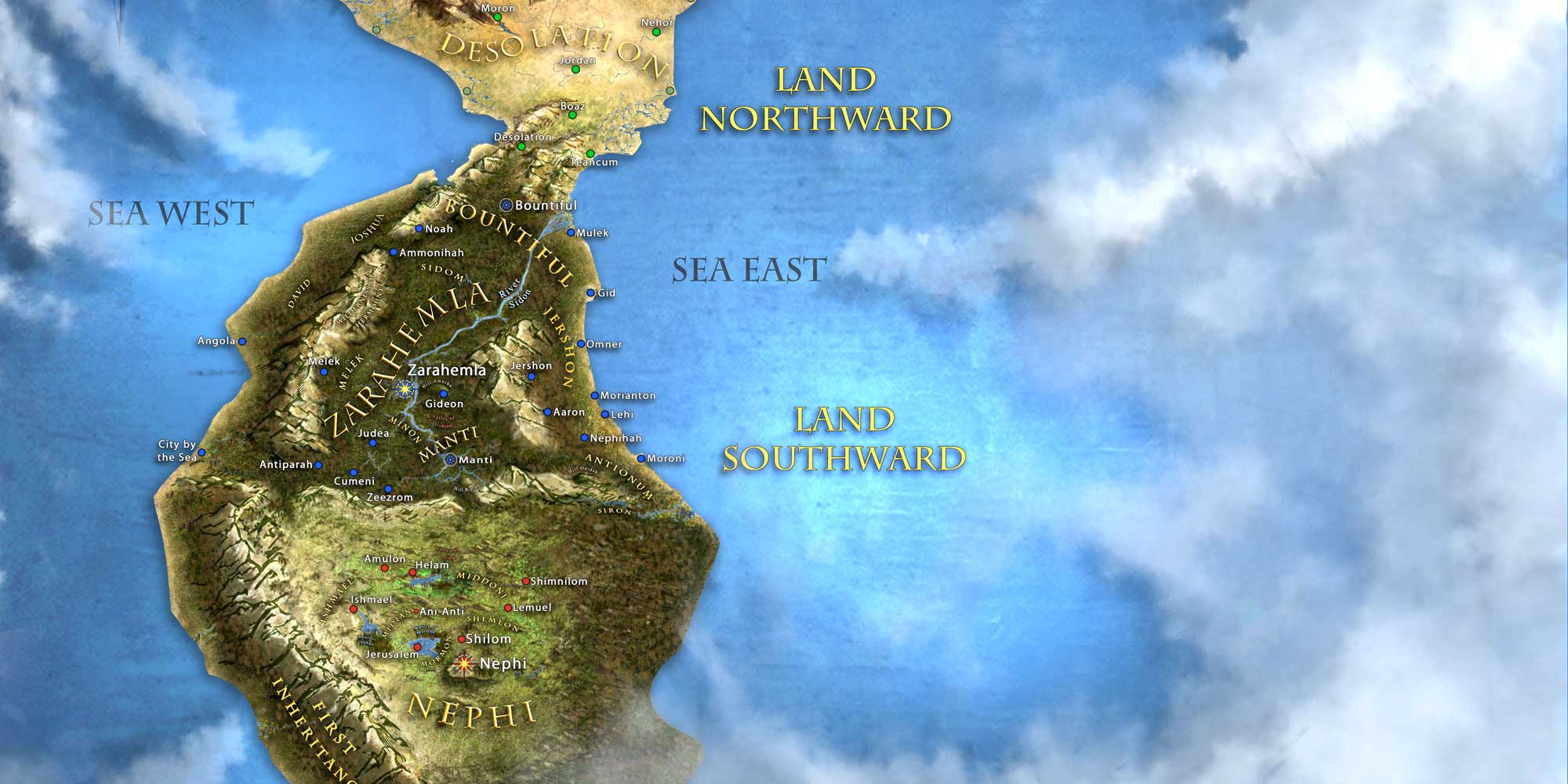
The Land of Promise
The Church of Jesus Christ of Latter-day Saints wrote:In Joseph Smith’s day, some individuals claimed that they had a gift to “see,” or receive divine or supernatural messages, through seer stones. These beliefs came from the Bible and from European cultural traditions brought to early America by immigrants. Joseph Smith and his family accepted these beliefs, and Joseph occasionally used stones he located in the ground to help neighbors find missing objects or search for buried treasure.
WELCOME to the Land of Promise from Joseph Smith’s Perspective


Principles of Direction, Elevation, and Land-formation will be Explained in this Thread


-
Shulem
- God
- Posts: 8773
- Joined: Wed Oct 28, 2020 1:40 am
- Location: Facsimile No. 3


-
Shulem
- God
- Posts: 8773
- Joined: Wed Oct 28, 2020 1:40 am
- Location: Facsimile No. 3


-
Shulem
- God
- Posts: 8773
- Joined: Wed Oct 28, 2020 1:40 am
- Location: Facsimile No. 3
America the Beautiful
Joseph Smith conceived ideas for the Book of Mormon at an early age. Martin Harris acted as a scribe when Smith was 22 years old. I’m convinced Joseph had already conceived fundamental ideas for his story when he was a lad working on his family’s farm in New York. His account of the angel Moroni appearing to him as a youth suggests that Joseph had already been thinking of the native Americans long before the country was founded and settled by Europeans. Mother Lucy Smith’s autobiography mentions how Joseph used to talk about the early inhabitants and how they lived. She said, “During our evening conversations, Joseph would occasionally give us some of the most amusing recitals that could be imagined: he would describe the ancient inhabitants of this continent; their dress, mode of travelling, and the animals upon which they rode; their cities, and their buildings, with every particular; he would describe their mode of warfare, as also their religious worship. This he would do with as much ease, seemingly, as if he had spent his whole life with them.” The Indians fascinated young Joseph. He was not well acquainted with science and had a limited understanding of many things that were out of reach for an uneducated farm boy. Nonetheless, Joseph was familiar with his vicinity and surrounding lands and had a basic understanding of geography. Access to maps were available to the public through various means and in the schools. Smith conceive his ideas about the Indians while in his youth although his knowledge and understanding of world history and advanced thinking was rather childlike or ignorant; to Joseph, the world was an adventure, full of mystery and wonder yet to be explored and accomplished.
Smith was fascinated with treasure seeking while a youth and later as the Lord’s treasure-prophet while visiting Salem. But the prophet failed to produce the treasure in which he diligently sought. Joseph Smith used maps. Maps are guides that show the way and provide the needed details of what exists beyond. Young Joseph was familiar with the maps of his day, especially the United States of America as it existed in his time. The Book of Mormon makes it clear that America is a great treasure to be had and that those who possess it are living in the “promised land.”
Note that Lehi & Nephi prosper in the land of promise:
The “choice” land above all other lands is AMERICA proper! The “choice” land in Joseph Smith’s mind (at that time) was not referencing an entire hemisphere but the political nature of government that oversees *that* choice land. Stars and stripes waving in the breeze! That is the choice land in which Smith envisioned:
Red, white, blue
When Joseph conceived ideas for his book, he knew that he would write about two civilizations to include the Nephites and the Jaredites. That was his plan. The story of the first civilization is given at the end of the book. However, the Jaredites are mentioned early in the book and therefore were probably mentioned in the 116-page lost manuscript. But let’s focus on the Nephites and *their* land of promise.
Lehi was the founder of the Nephite civilization. They disembarked on the land of promise and immediately went to work raising crops and making a homestead. The geography of the story makes it clear that Lehi’s first inheritance is the southernmost part in which to move into land going northward. Everything else was north or down into the land where it would continue. The land of Nephi was nearly surrounded by water from the sea east, sea west, and sea south. Going north was in a sense like going down into the land and into the continent because there was no other way to go. The mention of elevation per-se was not necessarily literal but is included in the story for special effect and to give the sense that Lehi’s cradle of land is the upmost region at the end of the southern line. Smith may have alluded to elevation as part of the “up” and “down” with regards to the land of Nephi and how it relates to the rest of the peninsula but the map doesn’t give indication of elevation so either Smith interpreted the elevation that way at the southern tip of the peninsula or he invented that aspect to reflect elevation. But the bottom line is that the tip was the birth place or cradle in which Lehi landed and there was nowhere else to go but northward -- ever onward and it was termed “down” in the text. Everything else goes down or north into the continent or, it could be said to go up into the continent depending on the expression. The land of Nephi is at the southern end of the peninsula. Thus, the land of Nephi was a southern land and Zarahemla was further north.
Joseph Smith envisioned Lehi’s family sailing the ocean in a ship which was built by their own hands, making their way to the land of promise which is choice above all other lands. Smith imagined Lehi sailing into the Arabian Sea and then going south into the Indian Ocean and making a hook around Africa. From there they sailed north into the Atlantic and made a straight line to the land of promise, America.
_______________________________________________________________
_______________________________________________________________
_______________________________________________________________
Yes, the United States of America was the land of promise
and Philadelphia & Washington DC are the hubs of liberty in which
Smith envisioned within Book of Mormon geography!
_______________________________________________________________
_______________________________________________________________
_______________________________________________________________
Smith was fascinated with treasure seeking while a youth and later as the Lord’s treasure-prophet while visiting Salem. But the prophet failed to produce the treasure in which he diligently sought. Joseph Smith used maps. Maps are guides that show the way and provide the needed details of what exists beyond. Young Joseph was familiar with the maps of his day, especially the United States of America as it existed in his time. The Book of Mormon makes it clear that America is a great treasure to be had and that those who possess it are living in the “promised land.”
Note that Lehi & Nephi prosper in the land of promise:
1 Nephi 2:20 wrote:Ye shall prosper, and shall be led to a land of promise; yea, even a land which I have prepared for you; yea, a land which is choice above all other lands.
The “choice” land above all other lands is AMERICA proper! The “choice” land in Joseph Smith’s mind (at that time) was not referencing an entire hemisphere but the political nature of government that oversees *that* choice land. Stars and stripes waving in the breeze! That is the choice land in which Smith envisioned:
Red, white, blue
When Joseph conceived ideas for his book, he knew that he would write about two civilizations to include the Nephites and the Jaredites. That was his plan. The story of the first civilization is given at the end of the book. However, the Jaredites are mentioned early in the book and therefore were probably mentioned in the 116-page lost manuscript. But let’s focus on the Nephites and *their* land of promise.
Lehi was the founder of the Nephite civilization. They disembarked on the land of promise and immediately went to work raising crops and making a homestead. The geography of the story makes it clear that Lehi’s first inheritance is the southernmost part in which to move into land going northward. Everything else was north or down into the land where it would continue. The land of Nephi was nearly surrounded by water from the sea east, sea west, and sea south. Going north was in a sense like going down into the land and into the continent because there was no other way to go. The mention of elevation per-se was not necessarily literal but is included in the story for special effect and to give the sense that Lehi’s cradle of land is the upmost region at the end of the southern line. Smith may have alluded to elevation as part of the “up” and “down” with regards to the land of Nephi and how it relates to the rest of the peninsula but the map doesn’t give indication of elevation so either Smith interpreted the elevation that way at the southern tip of the peninsula or he invented that aspect to reflect elevation. But the bottom line is that the tip was the birth place or cradle in which Lehi landed and there was nowhere else to go but northward -- ever onward and it was termed “down” in the text. Everything else goes down or north into the continent or, it could be said to go up into the continent depending on the expression. The land of Nephi is at the southern end of the peninsula. Thus, the land of Nephi was a southern land and Zarahemla was further north.
Joseph Smith envisioned Lehi’s family sailing the ocean in a ship which was built by their own hands, making their way to the land of promise which is choice above all other lands. Smith imagined Lehi sailing into the Arabian Sea and then going south into the Indian Ocean and making a hook around Africa. From there they sailed north into the Atlantic and made a straight line to the land of promise, America.
Alma 46:16,17 wrote: And therefore, at this time, Moroni prayed that the cause of the Christians, and the freedom of the land might be favored.
And it came to pass that when he had poured out his soul to God, he named all the land which was south of the land Desolation, yea, and in fine, all the land, both on the north and on the south—A chosen land, and the land of liberty.
_______________________________________________________________
_______________________________________________________________
_______________________________________________________________
Yes, the United States of America was the land of promise
and Philadelphia & Washington DC are the hubs of liberty in which
Smith envisioned within Book of Mormon geography!
_______________________________________________________________
_______________________________________________________________
_______________________________________________________________
Last edited by Shulem on Sun Feb 20, 2022 5:30 pm, edited 1 time in total.
-
Shulem
- God
- Posts: 8773
- Joined: Wed Oct 28, 2020 1:40 am
- Location: Facsimile No. 3
The Land of Nephi
Land of Nephi
Alma 22:7 wrote:And it came to pass that the king sent a proclamation throughout all the land, amongst all his people who were in all his land, who were in all the regions round about, which was bordering even to the sea, on the east and on the west, and which was divided from the land of Zarahemla by a narrow strip of wilderness, which ran from the sea east even to the sea west, and round about on the borders of the seashore, and the borders of the wilderness which was on the north by the land of Zarahemla, through the borders of Manti, by the head of the river Sidon, running from the east towards the west—and thus were the Lamanites and the Nephites divided.
- All the land of Nephi is as a strip of wilderness surrounded by water
- East coast
- West coast
- East & West coast designations means the narrow strip of land runs north to south
- The narrow strip of the Land of Nephi is divided from Zarahemla by River Sidon and flanked by the seas
- The River Sidon separates the two lands
Alma 50:11 wrote:And thus he cut off all the strongholds of the Lamanites in the east wilderness, yea, and also on the west, fortifying the line between the Nephites and the Lamanites, between the land of Zarahemla and the land of Nephi, from the west sea, running by the head of the river Sidon—the Nephites possessing all the land northward, yea, even all the land which was northward of the land Bountiful, according to their pleasure.
Alma 56:25 wrote:Neither durst they march down against the city of Zarahemla; neither durst they cross the head of Sidon, over to the city of Nephihah.
Don’t take this map as an exact science. Smith’s geography was simple and straightforward and he built it within the stories of his novel. Only Joseph knew where his Zarahemla really was. He didn’t tell anyone -- not even his dear associate, Oliver Cowdery. The geography was Smith’s secret held close to his heart and would remain a mystery. A land which is choice above all other lands being the land the Lord had prepared and preserved for a chosen people as a land of liberty where 13 stars and stripes would fly proudly on the American flag. It was only later that the idea of the promised land extended beyond the Colonies to include Central and South America. Those territories were never part of the original plan but were later adopted by the saints as a matter of faith promoting convenience in the hopes of archeological evidence.
The River Sidon is a very important feature in the Book of Mormon story and narrative. It’s a river that runs north and south and east and west. It varies in width and complexity. Smith used what basic maps were at his disposal to determine that there were rivers on the peninsula and that they empty into the mouth of the west Chesapeake Bay. Smith’s geography remained a secret with him and he could do whatever he wanted with it including the river. But the basic format to include the land being nearly surrounded by water and hanging from a narrow neck with the land northward is central to the whole geography. The narrow neck is the key in identifying the peninsula described in the Book of Mormon. Anyone who has seriously researched this subject knows that the narrow neck is key to understanding the whereabouts of Bountiful and Desolation. But Smith could do whatever he wanted with his river and used it in his stories throughout the book. There are a couple of large rivers running in the peninsula and into the bay that certainly fit the description in which Smith was working. It need not be perfect because it was all done in anonymous format. There could have been multiple Sidon rivers as far as Smith was concerned.
-
Shulem
- God
- Posts: 8773
- Joined: Wed Oct 28, 2020 1:40 am
- Location: Facsimile No. 3
“Nearly surrounded by water”
Alma 22:32 wrote:And now, it was only the distance of a day and a half’s journey for a Nephite, on the line Bountiful and the land Desolation, from the east to the west sea; and thus, the land of Nephi and the land of Zarahemla were nearly surrounded by water, there being a small neck of land between the land northward and the land southward.
In other words, the land is almost, but not quite, AN ISLAND! Smith’s presentation of the land of Nephi in how it relates to the ocean and the land leading into the north via the narrow neck is indicative of nearly being on an island which is completely surrounded by water. But in this case the land is “nearly” surrounded by water which allows us to reason that Smith was visualizing a piece of land that was surrounded on three sides by ocean with the northern end leading through the narrow neck, thus we are dealing with a PENINSULA! The very definition of a peninsula is: A piece of land almost surrounded by water or projecting out into a body of water.
Websters 1828 wrote:PENIN’SULA, noun [Latin pene, almost, and insula, an isle.]
1. A portion of land, connected with a continent by a narrow neck or isthmus, but nearly surrounded with water. Thus Boston stands on a peninsula
Nearly surrounded by water implies that the vast majority of the land has coastline! It would therefore be reasonable to say that “nearly surrounded” means literally that, “NEARLY SURROUNDED” and if the land is surrounded by ocean, then that means it’s a peninsula, period. In the case of the Book of Mormon peninsula the only escape is through the narrow neck leading to the north. There is no escape beyond the cradle of the south. That’s the end of the line. Nobody was ever reported to having gone south of Lehi’s First Inheritance. All roads led north! All that exist south of the land of Nephi is ocean and a coastline surrounds the very land in which Lehi landed. That is why we never hear about anyone ever going south of the land of Nephi. Everything leads north through the isthmus or narrow slip of land.
Folks, this makes a solid case for the Delmarva Peninsula. It just can’t get any clearer or concise other than Smith afterward coming out and naming it which he didn’t for obvious reasons. The land was surrounded with water, nearly surrounded, like an island hanging out in the ocean connected only by a small neck of land. Little wonder Nephi said, “we have been driven out of the land of our inheritance; but we have been led to a better land, for the Lord has made the sea our path, and we are upon an isle of the sea.”
Thus, the land of Nephi really was like being on an isle of the sea and the circumference of the land was surrounded by coastline except at the small neck of land. That is exactly what Smith saw when he looked at Delaware as it adjoins to Maryland on the map. And remember that Lehi’s landing was the southernmost place mentioned in the story, there being no other direction to go but north.
And it came to pass that the Nephites had inhabited the land Bountiful, even from the east unto the west sea, and thus the Nephites in their wisdom, with their guards and their armies, had hemmed in the Lamanites on the south, that thereby they should have no more possession on the north, that they might not overrun the land northward.
Notice that Alma Joseph Smith tells us that the Nephites had “hemmed in” the Lamanites to the south. There was no way they could pass through the narrow neck of land and enter and possess the north. They were hemmed in on the peninsula like being out on an isle of the sea. There was nowhere to go outside their island-like home. The Lamanites were trapped and the ONLY way they could enter the northern lands was to go through the narrow neck or build ships like Hagoth did and sail through the bay into the rivers leading up into the interior of the northern country. But the story never mentions Lamanites building ships because they were primitive and less industrious than their fair and white brethren, the Nephites.
Therefore the Lamanites could have no more possessions only in the land of Nephi, and the wilderness round about. Now this was wisdom in the Nephites—as the Lamanites were an enemy to them, they would not suffer their afflictions on every hand, and also that they might have a country whither they might flee, according to their desires.”
“ROUND ABOUT” being the key! The Lamanites were confined to the peninsula with nowhere to go but the peninsula itself. Being cut off from entering the narrow neck they were in effect like being on an island completely surrounded by water. If the Lamanites were to escape the isle, they would have to defeat the Nephites at the narrow neck in order to go north as they did later in the story.
Delmarva fits the story like a glove!

Apologists who embrace the various narrow neck models fail to understand (or admit) the basic geographical understanding in the Book of Mormon wherein the story makes it clear that there is no land south of the land of Nephi. Nothing but ocean exists south of Lehi’s landing. After landing in the promised land there was nowhere to go but north -- ever northward into the body of the peninsula and eventually discovering the river Sidon which separated the eastern land of Nephi from the main body of the peninsula that was westward and ever northward. Nobody in the Book of Mormon, from the days of Jared to Lehi and finally Moroni, ever stepped foot south of Lehi’s landing. The only thing that is ever mentioned that may be construed as being south of Lehi’s landing is “sea south”.
This makes for a strong argument that the land being “nearly surrounded by water” was not an isthmus or a neck annexed by landforms at both north and south -- but a true peninsula. The Delmarva Peninsula fits this paradigm like a glove. In fact, it’s the only geographical model that meets the basic areal landform or shape that connects to the main body of the continent.
“Nearly surrounded by water”
6,000 square miles
2000 miles of coastline
12 miles of isthmus connected to the north
Nephi wrote:we are upon an isle of the sea
12 miles connected to the northern land. It’s like being on an island nearly surrounded by water.

The only thing south of the land of Nephi is the ocean.
-
Shulem
- God
- Posts: 8773
- Joined: Wed Oct 28, 2020 1:40 am
- Location: Facsimile No. 3
Narrow Neck Defined
Alma 22:31,32 wrote:And they came from there up into the south wilderness. Thus the land on the northward was called Desolation, and the land on the southward was called Bountiful, it being the wilderness which is filled with all manner of wild animals of every kind, a part of which had come from the land northward for food.
And now, it was only the distance of a day and a half’s journey for a Nephite, on the line Bountiful and the land Desolation, from the east to the west sea; and thus the land of Nephi and the land of Zarahemla were nearly surrounded by water, there being a small neck of land between the land northward and the land southward.

You’ve read the statement made by Alma many times and you think you understand it, but do you? It’s a day and a half’s journey for a Nephite -- but a journey through what? The land of Desolation is located north of the narrow neck and Bountiful is located south of the neck. That seems simple enough or does it? Apologists have assumed the day and a half was the distance across the WIDTH of the narrow neck from Sea West to Sea East, but is it?
No! It’s not the distance of the WIDTH of the narrow neck from side to side or east to west! That is not what the author implied. It’s the distance of the LENGTH of the narrow neck from north to south, the length of the neck between the seas! In other words, it’s not a distance measured on a horizontal run from east to west but a vertical run from north to south!
1) “on the line Bountiful”
2) “and the land Desolation”
3) “from the east”
4) “to the west sea”
5) “a small neck of land”
6) “between the land northward and the land southward”
In other words, the distance is measured from Bountiful’s northern horizontal border which is “on the line Bountiful” to the southern horizontal border of Desolation!
From border to border, north and south, leading through the narrow neck that is flanked by the seas!
Psyche!

The “distance” is what it takes for a soldier to march from the line Bountiful going north through the narrow neck until reaching Desolation. It’s “the journey for a Nephite” soldier to make the march in average time. It’s not a reference to a marathon or a race but the amount of time it takes a soldier to march the distance from point A to point B. That’s what the author meant regarding the distance of the narrow neck in the above reference. Hence, the distance is what it takes to traverse the narrow neck from north to south or from south to north across and through the narrow neck. It’s the distance from the line Bountiful to the land Desolation!
BUT what about the distance of the narrow neck from side to side, or from east to west -- the actual WIDTH of the neck that separates the two lands? Everyone has wrongly assumed it was a day and a half because they have misinterpreted Joseph Smith’s words. But, behold, the Book of Mormon gives us an exact answer to that question and it’s not something the apologists take kindly to. Not at all! They obfuscate Smith’s words in order to appease their listeners and defend the Church at any cost.
We learn in Helaman 3 that there were mass Nephite migrations from Zarahemla and the southern lands northward of the narrow neck. The northern lands became greatly populated even to a great distance where there were large bodies of water and many rivers. Helaman 4 tells of war between the Nephites and Lamanites; moreover, the campaigns of the Lamanites were so successful “they succeeded in obtaining possession of the land of Zarahemla; yea, and also all the lands, even unto the land which was near the land Bountiful.”
This is when we learn that “the Nephites and the armies of Moronihah were driven even into the land of Bountiful” with their backs to the narrow neck they faced the approaching Lamanites to the south who had taken all the lands south. The Nephites had no choice other than to stand their ground and fight or flee into the land northward. The Nephites stood there ground and went down to battle against the Lamanites and in time they regained half the territory.
Now, with that said, prior to the time when the Nephites regained territory from the Lamanites and while their backs were up against the narrow neck and left to defend Bountiful we are given the GOLDEN KEY for the narrow neck of land!
It would have been utterly disastrous if the Lamanites had penetrated the narrow neck and entered the northern lands with the Nephites being held up in Bountiful! That would have been a worse case scenario from a military point of view. The Nephites did not flee northward but elected to stand their ground and fight!
And so, the most important thing they could do at this juncture was to secure the narrow neck and all the passes that lead through it! And therefore, they “fortified and stationed their armies to defend their north country”; thus, they placed their military on a line to defend the narrow neck from all who dare to penetrate! They fortified the line, plugged the holes, and defended the north country!
And in that same verse (Helaman 4:7) we are given the GOLDEN KEY to the narrow neck which tells us exactly how WIDE the neck is on a line from sea to sea:
“a day’s journey for a Nephite”
Or in other words, it takes a Nephite a day to traverse the narrow neck on a horizonal line!
Helaman 4:7 wrote:And there they did fortify against the Lamanites, from the west sea, even unto the east; it being a day’s journey for a Nephite, on the line which they had fortified and stationed their armies to defend their north country.
The Isthmus of Delmarva on the “line” Bountiful from sea west to sea east is a day’s journey for a Nephite soldier!
1 day!
THE NARROW NECK IS THE GREAT DIVIDE BETWEEN NORTH AND SOUTH
Mormon 2:29 wrote:And the Lamanites did give unto us the land northward, yea, even to the narrow passage which led into the land southward. And we did give unto the Lamanites all the land southward.
DEFEND THE LINE ON THE NARROW NECK
Mormon 3:5,6 wrote:And it came to pass that I did cause my people that they should gather themselves together at the land Desolation, to a city which was in the borders, by the narrow pass which led into the land southward
And there we did place our armies, that we might stop the armies of the Lamanites, that they might not get possession of any of our lands; therefore we did fortify against them with all our force.
THE LINE BREAKS AND THE CITY OF DESOLATION IS TAKEN!
Mormon 4:1,2 wrote:AND now it came to pass that in the three hundred and sixty and third year the Nephites did go up with their armies to battle against the Lamanites, out of the land Desolation.
And it came to pass that the armies of the Nephites were driven back again to the land of Desolation. And while they were yet weary, a fresh army of the Lamanites did come upon them; and they had a sore battle, insomuch that the Lamanites did take possession of the city Desolation, and did slay many of the Nephites, and did take many prisoners.
The rest of Mormon’s story informs us that the Nephites continued to wage war and defend their lands doing everything they could to win back their lands and cities, especially Desolation. Defending the cities to the north of the narrow neck was vital if they were to survive and maintaining a fortified line along the narrow neck was the only way they could keep the Lamanites in check and safeguard the northern territory. But the Nephites failed. The Lamanites took the narrow neck and drove the Nephites northward until the final battles commenced at Cumorah.
BOUNTIFUL AND THE NARROW NECK
Let’s look again at how the land Bountiful and the city therein was positioned on the map as it relates to the narrow neck that leads into the land northward wherein the land of Desolation is almost immediately situated.
But first, understand that the lands south of the narrow neck were at this time managed by the Nephites all the way to the head of River Sidon from Sea East to Sea West. Essentially, the Nephites possessed all the land north of the land of Nephi (Delmarva tail) which was the main habitation and capital of the Lamanites “the land of Nephi did run in a straight course from the east sea to the west” (Alma 50:8). However, the Nephites struggled to maintain their southern sector wherein constant Lamanite incursion from the far south threatened their peace and sovereignty.
Alma 22:29 wrote:And also there were many Lamanites on the east by the seashore, whither the Nephites had driven them. And thus the Nephites were nearly surrounded by the Lamanites; nevertheless the Nephites had taken possession of all the northern parts of the land bordering on the wilderness, at the head of the river Sidon, from the east to the west, round about on the wilderness side; on the north, even until they came to the land which they called Bountiful.
Clearly there is a dividing line between Desolation and Bountiful and the land in-between is the narrow neck which is positioned on a perfect vertical axis, running north and south, being flanked by Sea West and Sea East.
Alma 22:31 wrote: And they came from there up into the south wilderness. Thus the land on the northward was called Desolation, and the land on the southward was called Bountiful, it being the wilderness which is filled with all manner of wild animals of every kind, a part of which had come from the land northward for food.
To the north is Desolation and to the south is Bountiful. The narrow neck lies in-between the two lands. The distance between Bountiful and Desolation is a day and a half’s journey.
Alma 22:32 wrote: And now, it was only the distance of a day and a half’s journey for a Nephite, on the line Bountiful and the land Desolation, from the east to the west sea; and thus the land of Nephi and the land of Zarahemla were nearly surrounded by water, there being a small neck of land between the land northward and the land southward.
The land Bountiful spanned the entire sector south of the narrow neck leading from Sea East to Sea West. The city limits of Bountiful was within that land. Thus, the land of Bountiful was a complete buffer between the narrow neck and all the lands south of Bountiful. Nothing could get through the narrow neck without first going through Bountiful! The land Bountiful was a line leading from sea to sea, south of the narrow neck.
Alma 22:33 wrote: And it came to pass that the Nephites had inhabited the land Bountiful, even from the east unto the west sea, and thus the Nephites in their wisdom, with their guards and their armies, had hemmed in the Lamanites on the south, that thereby they should have no more possession on the north, that they might not overrun the land northward.
The people of Ammon were given the land of Jershon which was situated south of the land of Bountiful and bordered along the Sea East.
Alma 27:22 wrote:And it came to pass that the voice of the people came, saying: Behold, we will give up the land of Jershon, which is on the east by the sea, which joins the land Bountiful, which is on the south of the land Bountiful; and this land Jershon is the land which we will give unto our brethren for an inheritance.
Here we clearly see that there is a line maintained by the Nephites in defending their northern territory running from sea to sea. Key to this is that the Nephites controlled all the land north of Bountiful and in order to do that they must hold the line Bountiful which leads into the narrow neck.
Alma 50:11 wrote:And thus he cut off all the strongholds of the Lamanites in the east wilderness, yea, and also on the west, fortifying the line between the Nephites and the Lamanites, between the land of Zarahemla and the land of Nephi, from the west sea, running by the head of the river Sidon—the Nephites possessing all the land northward, yea, even all the land which was northward of the land Bountiful, according to their pleasure.
Losing Bountiful will result in leaving the narrow neck vulnerable to incursion.
Alma 51 wrote:28 And it came to pass that they marched to the borders of the land Bountiful, driving the Nephites before them and slaying many.
30 And it came to pass that he headed Amalickiah also, as he was marching forth with his numerous army that he might take possession of the land Bountiful, and also the land northward.
Holding the line across Bountiful from sea to sea was an absolute must! Plugging the holes, guarding the passes, and fortifying every point along the horizonal axis was essential in preventing a Lamanite invasion through the narrow neck.
Alma 52:9 wrote:And he also sent orders unto him that he should fortify the land Bountiful, and secure the narrow pass which led into the land northward, lest the Lamanites should obtain that point and should have power to harass them on every side.
If the city Bountiful is taken then the narrow neck is open season!
Alma 52:27 wrote:And it came to pass that the Lamanites did pursue Teancum until they came near the city Bountiful, and then they were met by Lehi and a small army, which had been left to protect the city Bountiful.
If the city of Bountiful falls and “the line which was between the land Bountiful and the land Desolation” (3 Nephi 3:23) is breached then there is nothing left to secure the narrow neck and the Lamanites can run though and possess the northern lands!
Helaman 1:23 wrote:And now he did not tarry in the land of Zarahemla, but he did march forth with a large army, even towards the city of Bountiful; for it was his determination to go forth and cut his way through with the sword, that he might obtain the north parts of the land.
Last edited by Shulem on Wed Feb 23, 2022 9:55 pm, edited 1 time in total.
-
Shulem
- God
- Posts: 8773
- Joined: Wed Oct 28, 2020 1:40 am
- Location: Facsimile No. 3
REQUIRED READING
I want to remind readers that they should not shortchange themselves but should read the original thread. This thread was made as a supplement to introduce the original thread. If you find the subject interesting then by all means read the other thread. Or do what you want. I don't care. I'm tired of this for right now. I've spent a lot of time trying to explain this stuff to others and I need a break. I do have much more to explain and reveal but am not up to it at present.
Shulem Cracked the Book of Mormon Code, the Land of Nephi is now revealed! See for yourself! The Golden Key!
Shulem Cracked the Book of Mormon Code, the Land of Nephi is now revealed! See for yourself! The Golden Key!
Last edited by Shulem on Thu Feb 24, 2022 10:06 pm, edited 2 times in total.
-
Shulem
- God
- Posts: 8773
- Joined: Wed Oct 28, 2020 1:40 am
- Location: Facsimile No. 3
Re: The Cradle of Nephite Civilization
The southern tip of Delmarva is where the story begins in the New World. *That* is the very location where Lehi landed and built a homestead as a group and family. We are given little information (1 Nephi 18:23-25) about the original colonization of Lehi’s family in the new world. Nephi and his brethren worked jointly in building a colony, unfortunately family cohesion failed due to strife and political differences. Here is a basic look at logistics after landing on the peninsula:
• Pitch tents and plant crops
• Expedition into the wilderness revealed animals of all kinds in the forests
• All manner of ore is found
Very shortly thereafter, Lehi died and was buried. Immediately thereafter, there was a falling out between Nephi and his brethren and they separated. Nephi took his family and journeyed into the wilderness, (northward) for the space of many days and called the place “Nephi”. Nevertheless, Nephi and his family didn’t travel very far, just enough to provide some distance and space where they could build a colony away from their estranged brethren.
Let me make one thing absolutely clear and state for the record that there is nothing, ABSOLUTELY NOTHING, ever mentioned in the Book of Mormon about anything ever existing SOUTH of Lehi’s first inheritance other than the south sea. Their original landing was the most SOUTHERN place ever mentioned in the entire Book of Mormon! There was nothing south of that place. Everything was north because Lehi’s landing was at the southernmost part of the peninsula which is described in the text as a body of land nearly surrounded by water and the only escape from that body was through the narrow neck leading northward into Desolation and beyond.
I hold the line and defy the apologists to make something of it! I’m holding my ground right here at the southern tip of the land of Nephi because I know the apologist have nothing in the Book of Mormon that takes anything south of that point. It’s a roadblock in which they cannot pass because there is nothing south of that land other than the south seas. This *IS* a nightmare scenario for the apologists and strikes a fatal blow to all the Mesoamerican apologetic models. Lehi’s gravesite marks the furthest southern point of Nephite civilization. There is no other direction to go other than north.
In an effort to reinforce this position, I will quote statements I made in the original thread because I want to make it abundantly clear that I will not give ground and will fight to the death by holding the line. Apologists, beware, you will fail! It’s vitally important that I hold this ground because proving that the land was a peninsula rather than a true isthmus is absolutely catastrophic for the apologists and big win for me.
Wash, Rinse, and Repeat:
Lehi was the founder of the Nephite civilization and disembarked on the land of promise and immediately went to work raising crops and making a homestead. The geography of the story makes it clear that it is the beginning of their land being also the southernmost part in which to move into the rest of the lands going northward. Everything else was north or down into the land where it would continue. The land of Nephi was nearly surrounded by water from the sea east, sea west, and sea south. Going north was like going down into the land and into the continent. The mere mention of elevation (up/down) is not always literal but is added into the story for special effect and to give the sense that the cradle of civilization is the first habitation and is at the end of the southern tail of the peninsula. From the southern tip, everything else goes up or down -- heading north into the continent. Thus, the land of Nephi was the southernmost land and Zarahemla was to the north on the main body of the peninsula.
Lehi landed on the southern end of the peninsula at the base of Virginia’s tip. That is the cradle or the birthplace in which the Nephite civilization began. From that point, facing the south sea there was nowhere to go other than due north. To leave the territory of Lehi’s burial would result in going north to Zarahemla, Bountiful, and ultimately through the narrow neck leading to the land of the north. Once one passed through the narrow neck they are now on the open continent in which they may go north or turn east or west and eventually cross rivers and from there go south into what is now Jersey or Maryland. But ultimately it was all the land of promise (USA) and that is what was *in* the heart of Joseph Smith’s secret geographical narrative. The Tehuantepec and Yucatan base have absolutely nothing to do with Smith’s Book of Mormon. It was the farthest thing from his mind at that time.
The geography intermingles and seems fluid with a back and forth like motion within the large fluid zone of Book of Mormon geography. The cradle of civilization began with Lehi’s landing. That is the furthest point south in the entire story. Nobody ever went south of Lehi’s first inheritance! Everything is north! The original inheritance or first landing is the base upon which the story is built up and ultimately ends up in Jaredite territory to the far north. The geography bears a sense of interconnectedness as if the southern land of Nephi is accessible to the far north but doing so requires a well-planned expedition having provisions and means to transport in order to traverse land and river. Clearly, from what I gather there is a back and forth between the far south and the far north. We are informed that there were roads and means to transport people and things. Later in the book when civilization flowered, we are given the impression that there was a network of transportation and intercommunications between cities and regions through a supply chain and civilized means to connect everyone into one massive civilization. The more I think about this and process Smith’s story into my own perception it is intolerable/impossible to adopt Central America and northern New York as the actual fluid zone in which the Nephites and Lamanites intermingled.
Every time the “land of promise” is mentioned in the Book of Mormon it is rooted within the concept that it is America proper, the very soil in which George Washington and the framers of the Constitution established liberty through free government on the choice spot of ground reserved for that very purpose. Mexico, Central America, and South America may be excluded from the map because they are irrelevant to the story. The concept of freedom and liberty evolves around Joseph Smith’s American homeland and ultimately the Hill Cumorah! The Book of Mormon is a kind of spoof where Smith used a modern map to invent his story, beginning at Delmarva. Once one begins to recognize the map and story relationship it becomes obvious that Smith was making stuff up.
Sea-WEST, sea-EAST, and sea-SOUTH are at Delmarva. Remember, the southernmost land where Lehi landed is the end of the line in the Book of Mormon. Nobody ever sailed south! Nobody ever marched south of Lehi’s original landing! All roads and all destinations led northward. The tip of Delmarva was the end, Lehi’s cradle in which civilization went northward from there. That was the tip of the peninsula and for all intents and purposes the southernmost place of Book of Mormon geography. Below is a well-done model proposed by Apologists. Note how it looks just like Delmarva but refuses to show the southernmost land or anything that might be imagined south of Lehi’s landing. It remains a mystery in the mind of the apologists so they leave a grey area completely unexplored and incomprehensible. The land south of Lehi’s landing is literally cut off and becomes like the end of the world or the edge of an unknown map. They can’t go any further because the Book of Mormon doesn’t give them license to do so and they know that. I find it incredible that they have not come to terms that Lehi landed on a true peninsula and that there is NOTHING south of that other than sea south. Nonetheless, the map below is well done and an accurate depiction of the land-form being connected to the northern land via a narrow neck that takes only a day and a half for soldiers to traverse.
South Sea is here as the land of Nephi is nearly surrounded by water
The above apologetic model is a good depiction of the land-form described in the Book of Mormon except for taking license and showing ghost-land south of Lehi’s first inheritance and omitting the “sea south” from the map. The unauthorized suggestion of existing land south of Lehi’s landing is not justified by the text. Omitting “sea south” from the map implies there is only a “sea west” and a “sea east”. Where is the sea south and what does it border?
*IF* the apologists insist that their model is an isthmus rather than a peninsula, then it stands to reason that there cannot be a “sea south” in their fatally flawed model. In order for a “sea south” to materialize in their model, the land-form must be a peninsula.
The idea that they were on a peninsula and the Nephites were able to “hem” in the Lamanites to the south shows the land as nearly island-like. There was no way to go north except through the narrow neck. The Lamanites would ever be hemmed in and their kingdom limited to that region nearly surrounded by water except for the northern part leading through the narrow neck. Delmarva is the model that meets all the criteria used by Smith when he LOOKING at a MAP.
Lehi landed on the southern tip of the Delmarva peninsula, the State of Virginia. That is the beginning of the promised land according to the Book of Mormon covenant made to Nephi. The southern end of the peninsula is where Lehi landed and where they planted their seeds and began to colonize. Later, Nephi took his family with him and wandered a little northward within the narrow strip or tail of land for the space of many days and began his own colony apart from Laman & Lemuel. The narrow strip of land looks like a tail leading up to the first river that empties into the Chesapeake Bay. The tail of land adjoins the southern narrow strip and is THE LAND OF NEPHI. The first river is Sidon. The main branch of the Sidon runs mostly south into the west sea. That river divides the land of Nephi from the land of Zarahemla located on the other side to the west. Hence, the land east of the river is the land of Nephi and Zarahemla is on the other side of the river. It was the long and narrow strip and river that separated the two lands. The coastal passage to the east led to the coastal city of Moroni or into Manti and ultimately Zarahemla.
Apologists who embrace various narrow neck Mesoamerican models fail to understand (or admit) the basic geographical understanding in the Book of Mormon wherein the story makes it clear that there is no land south of the land of Nephi. Nothing but ocean exists south of Lehi’s landing. After landing in the promised land there was nowhere to go but north -- ever northward into the body of the peninsula and eventually discovering Sidon which separated the eastern land of Nephi from the main body of the peninsula that was westward and ever northward. Nobody in the Book of Mormon, from the days of Jared to Lehi and finally Moroni, ever stepped foot south of Lehi’s landing. The only thing that is ever mentioned that may be construed as being south of Lehi’s landing is “sea south”. This makes for a strong argument that the land being “nearly surrounded by water” was not an isthmus or a neck annexed by landforms at both north and south -- but a true peninsula. The Delmarva peninsula fits this paradigm like a glove.
Mesoamerican apologists are aware that nothing in the thousand years of Book of Mormon history says anything about a land south of Lehi’s landing. The fact that nothing is mentioned regarding the natural resources available in the southern narrow neck of Central America and a massive continent annexed to the south is a sure sign that there never was anything south of Lehi’s landing other than the south seas. It’s inconceivable that Nephite and Lamanite governments would not have sent expeditions southward into Central America only to discover a continent as large as the continent to the north. There would have been expeditions and enquiry to what was down south. The resources and territories would have been staked and claimed. The Book of Mormon would have mentioned a southern long narrow neck and a continent that spanned endless wilderness and frontiers. Something, anything, would have been said about a southern land! The very absence of this evidence is proof that all that existed to the south of the land of Nephi was the ocean. The only evidence apologists have is in their imagination!
Apologists know the text of the Book of Mormon describes a peninsula and there is NOTHING in the Book of Mormon that justifies the introduction of an interconnecting land source being south of Lehi’s landing. The text of the Book of Mormon makes it clear that there is NOTHING south of that point other than “sea south” that rules all geography south of the land of Nephi (Helaman 3:8). In spite of careful geographical descriptions given in the text of the Book of Mormon, apologists have taken it upon themselves, giving themselves license to present the geography as if there is land south of Lehi’s landing. They do this BECAUSE there is no peninsula anywhere on the map that will fit their preconceived ideas and expectations of what is required to justify Book of Mormon claims with regards to archeology. What are they to do?
Here is an example of the Book of Mormon peninsula wherein apologists refuse to allow Lehi’s landing as the southernmost place and fail to recognize that “sea south” is all that exist south of the land of Nephi.
THE SEA SOUTH AND OCEAN BLUEApologist model wrote:
One glance at the many interesting hand drawn models of Book of Mormon lands make the all-important point of the narrow neck and attempt to keep it as narrow as possible. This abstract model at Book of Mormon Central is a prime example that shows how scholars take key elements from the story and put them to proportion in order to line things up to give proper orientation and size, especially with the narrow neck. Note that the lands of Bountiful, Zarahemla, Nephi, and Lehi’s First inheritance are given in proper order south of the narrow neck. Well done except for the fact that there is NOTHING south of Lehi’s inheritance other than coastline and ocean, thus the artist neglects to draw the tip of a true peninsula. Nobody went south of Lehi’s landing, ever, not ever! Everything in the entire Book of Mormon geography heads north because that is the only way/place to go.
- Land of Desolation
- Narrow Neck
- Bountiful
- Land of Zarahemla
- Land of Nephi
- Lehi’s first inheritance
Now with that said, allow me to point out that the narrow neck is the keystone to Book of Mormon geography like the Book of Mormon is the keystone to the Mormon religion! Likewise, Lehi’s first inheritance is the key to understanding the land truly was a peninsula because NOTHING is south of that point. It’s the southernmost point in the entire Book of Mormon whereby all that exists south of Lehi’s landing is the South Sea -- Ocean water -- the great brine.
- South Sea
A keystone is what holds the columns of an arch in place and completes the structure. The northern narrow neck of the peninsula is the keystone to Book of Mormon geography! Remove that narrow neck and everything crashes.
