**UPDATE** to Vern Holley Book of Mormon Place Names Theory

The catch-all forum for general topics and debates. Minimal moderation. Rated PG to PG-13.
User avatar
Shulem
God
Posts: 8853
Joined: Wed Oct 28, 2020 1:40 am
Location: Facsimile No. 3

Re: **UPDATE** to Vern Holley Book of Mormon Place Names Theory

Post by Shulem »

Craig Paxton wrote:
Mon Mar 17, 2025 2:22 am
So the most we can conclude I’d the Angola did exist as a place if only as a Post Office. Is it too much of a jump to assume that the Angola PO was thus named for the area in which it served? Especially since the town of Angola does in fact exist.

In early 1800’s post offices were generally named after Place Names: Post office names often mirrored the names of the communities they served, such as towns, townships, or neighborhoods.

Geographic Features: Names could also be inspired by nearby geographic features or man-made landmarks.

Is it a jump to say that Angola was named after the area that it served?

Craig,

Keep researching the subject. It looks fun.

But yes, it's a stretch to make the connection between Angola, the post office, and the future township of Angola within the Collins. Frankly, what you've done on this point is kind of what the apologists do in trying to make connections and parallels in defending indefensible Mormon claims. They look for anything that could be or something that is possible to save them from what obviously is easily dismissed as a false claim. But here, as critics, we need something substantial, something solid, we need bullseyes!

Hell yeah!

:D
Marcus
God
Posts: 8036
Joined: Mon Oct 25, 2021 10:44 pm

Re: **UPDATE** to Vern Holley Book of Mormon Place Names Theory

Post by Marcus »

Shulem wrote:
Mon Mar 17, 2025 3:52 am
Marcus wrote:
Mon Mar 17, 2025 3:01 am
I'm not a historian either, but yes, given that YOUR documentation shows that post offices had names different from their towns in multiple cases, I would say it IS too much of a jump.
I agree with Marcus on this point!

PS. Marcus, I'm hardly ever wrong. I'm nearly perfect.

:lol:
Don't I know it. 8-)
User avatar
Craig Paxton
Star B
Posts: 105
Joined: Tue Dec 22, 2020 9:55 pm

Re: **UPDATE** to Vern Holley Book of Mormon Place Names Theory

Post by Craig Paxton »

Before I get into the gist of my post, I wanted to state clearly that I believe the Book of Mormon to be a man made fiction written by Joseph Smith. I also strongly feel that Smith used many of the place names within his environment as seed material for his book. While many of Holly's assertions are flawed, especially as they relate to his Spaulding theory and city locations on his map, I believe that he was spot in his assertion that Smith used his environment as a source for place name materiel for his book.

Note: To the best of my knowledge some of what follows is new and some of it has been known for a long time but not brought together in the manner I am presenting it today. Please feel welcome to push back.

I have recently identified several additional references that strengthen the possibility that Joseph Smith was familiar with the place name Angola, one of the locations identified on the Vern Holly Map.

Why is this significant?

When Vern Holly published his "Book of Mormon Authorship: A Closer Look" in 1983 he leaned heavily on modern maps of the area surrounding Joseph Smiths boyhood home. Mormon apologists had an easy time pointing out that many of the place names Holly found had not even existed on maps that would been available to Smith. They were correct to also point out that the New York town, Angola hadn't even been incorporated until 1873. These F.A.I.R. arguments undermined Holly's assertion. For if the village of Angola was not incorporated until 1873, Smith surely wouldn't have known of nor heard of the name Angola early enough to have used it as a source for his book.

But that was then and this is now.

I have recently identified several additional references that strengthen the possibility that Joseph Smith could have been familiar with the place name Angola, one of the locations identified on the Vern Holly Map and could have even visited the location.

None of my finding are conclusive nor do they prove beyond doubt that Smith knew of the village of Angola. But I content that what I have discovered lessens the gap between his not being able to know of it's existence to it now being within reason for Smith to have been aware of its existence.

Enter the Quakers:

Jacob Taylor was a Quaker (Friend) who came from the Philadelphia area to western New York around 1809 as the leader of a Quaker mission. The mission was established to work with Native Americans and teach them agriculture, domestic skills, reading, and writing. Taylor and the other Quakers settled in what became known as Taylor's Hollow, in the present town of Collins, Erie County. This village later incorporated in 1873 under the name of Angola, New York. Taylor acquired approximately 300 acres in the area and established a substantial early settlement. Under his direction, the Quakers built cabins and, by about 1809, established both a sawmill and gristmill. The mills served both Native Americans and the growing number of white settlers moving into the region. Taylor subsequently became an important local figure. By 1814, sources indicate that he operated a sawmill, gristmill, and tavern, with the tavern serving travelers along the developing stage route.

How the name Angola enters the story:

Taylor's Hollow was not originally called Angola. But in 1822, when the area was still a small rural settlement, a post office was established there. The federal postal records give the establishment date as March 26, 1822, and identify Jacob Taylor as it's first postmaster. He named the post office Angola.

Why Angola?

My research has found that in the early 19th centuries, Quakers had become strongly associated with the abolition of slavery. Specifically, New York Quakers or Friends as they were also known, had directed their members to free their own enslaved people in 1777, and by 1790 there apparently were no Quaker slaveholders in the United States. Quakers subsequently became active in broader antislavery efforts. This movement led to effort to free slaves and return them to Africa. One of these efforts led to Quaker missions in Africa's Liberia and, here it is, Angola. The word Angola was well known in the New York area as an important region of Africa and as a major source to enslaved Africans. There was therefore already an established association between the word "Angola" and the African slave trade. New York itself had a direct historical connection to people from Angola through the Dutch colonial period. The naming of this post office Angola by Jacob Taylor was due to his being an anti slave Quaker and the Quakers connection with Africa. The Angola post office became an important link in the mail route in western New York.

So to recap, we know that the name Angola had been established as early as 1822 along an important mail route, well within the timeline necessary for Smith to have been aware of the names existence...but that is only the beginning and only proves that the name was in existence not that Smith could have been aware of its existence.

The more difficult question has been establishing a plausible connection between the young Joseph Smith, before the production of the Book of Mormon, and this relatively remote location. Angola was approximately 115 miles from the Smith family home in Manchester, New York, making it necessary to identify some historical evidence that could reasonably connect Joseph to the region.

And then I struck gold...ok maybe silver :-)

While I was familiar with Joseph Smith's 1826 glass-looking trial, I had never heard of one William D. Purple nor his role in the trial. But he becomes an important part of this story.

William D. Purple was not only present at the 1826 trial, he was asked to take notes by Justice of the Peace Albert Neely during the trial. In other words he took contemporaneous notes of the trial. Purple later published his recollection in 1877 using his notes as a refresher.

According to Purple, Joseph Smith gave a fairly detailed account of how he obtained one of his seer stones and how he traveled to find it.

Purple's account says that when Joseph was a young man, he heard about a neighboring girl, most likely Sally Chase, living about three miles away, who could look into a glass and see things that were hidden from others. Joseph eventually persuaded his parents to let him visit her. Most of us here are aware of Smith's 1826 Glass Looking Trial, so I won't re-plow that ground.

The account continues stating that…When he looked into her glass, which was placed in a hat to exclude the light, he said he saw a small stone located a great distance away. The stone became increasingly luminous until it appeared as bright as the midday sun.

According to Purple's account, Joseph described looking into this stone and seeing the other stone located approximately 150 miles away along the southern shore of Lake Erie, beneath the roots of a tree. The location was reportedly about a mile up a small stream, near the point where the stream entered the south shore of Lake Erie, close to the New York–Pennsylvania boundary.

Purple continued stating that Joseph became sufficiently interested in what he had claimed to have seen that he eventually left his father's home and traveled westward in search of the location. According to the recollection, Joseph took provisions and money with him but, when his resources became depleted, worked for a farmer for approximately three days. He then continued traveling westward for roughly 150 miles until he reached the mouth of the creek that he believed corresponded to the location he had seen in the stone.

One additional piece of this puzzle is that the known pre-1829 roads from the Smith home to Lake Erie show that the Angola/Taylor's Hollow area was connected to the developing road and postal network of western New York. A westward journey from the Smith family home near Palmyra to the southern shore of Lake Erie could therefore have passed through or near the Angola area.

Conclusion: To be clear, this account does not, by itself, prove that Joseph Smith visited Angola or that he was familiar with the location identified on the Vern Holly Map. It does, however, provide a potentially important piece of historical context. It places Joseph Smith, prior to the Book of Mormon, in an account involving a journey of approximately 150 miles westward to a location on or near the southern shore of Lake Erie, well within the same 115 mile distance to Angola from Palmyra and the general geographic region in which Angola was located.

Consequently, the question of Angola should not be dismissed solely because the village was incorporated in 1873 as F.A.I.R would want us to do. The historical evidence demonstrates that the name Angola was already established and in official use by 1822, and the Purple account provides an independent source that puts Joseph Smith in the region of western New York where Angola was located years before the Book of Mormon was written.

Taken together, these sources do not establish the identification conclusively, but they do appear to weaken the argument that Angola can be ruled out simply because its formal incorporation occurred after the Book of Mormon was written. At minimum, the evidence warrants a more careful examination of the historical use of the name Angola and Joseph Smith's movements through western New York during the years preceding the Book of Mormon.

Alias, much of the required historical record needed to get us to a beyond reasonable doubt position does not exists...but I feel that I provided enough evidence to have reopened the investigation to Vern Holly's theory that Smith used place names within his own backyard as source material for the place names in the Book of Mormon. The other Vern holly place names also need to be researched...my work continues.

New Reference:

https://catalog.archives.gov/id/75493318
U.S. Post Office Department, “Record of Appointment of Postmasters, 1814–1832,” Record Group 28, National Archives and Records Administration, National Archives Microfilm Publication M1131, vol. 3, entry for Angola, New York, established March 26, 1822; Jacob Taylor appointed postmaster March 26, 1822.
Last edited by Craig Paxton on Tue Aug 18, 2026 1:03 am, edited 1 time in total.
"...What many people call sin is not sin." - Joseph Smith

"Reality is that which, when you stop believing in it, doesn't go away" - Phillip K. Dick

“The meaning of life is that it ends" - Franz Kafka
User avatar
Limnor
God
Posts: 1738
Joined: Mon Sep 04, 2023 12:55 am

Re: **UPDATE** to Vern Holley Book of Mormon Place Names Theory

Post by Limnor »

This is a good find, Craig. You might find some additional correspondence if you overlaid not only Joseph, but Oliver, Parley and Rigdon’s documented pre-1830 travels over those names.

The Purple account about Smith traveling west may have correspondence to Pratt as well. Angola/Taylor’s Hollow lies southwest of Buffalo, between Buffalo and the Pennsylvania line, which is along the same line Pratt says he was traversing in his autobiography.
User avatar
Shulem
God
Posts: 8853
Joined: Wed Oct 28, 2020 1:40 am
Location: Facsimile No. 3

Re: **UPDATE** to Vern Holley Book of Mormon Place Names Theory

Post by Shulem »

Interesting for sure but inconclusive. Keep up the good work.

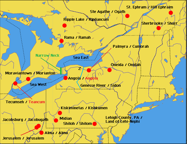
You're probably aware that I have spent a great deal of time sponsoring the Delmarva geography for Book of Mormon lands. Yes, I am convinced that Smith used Delmarva to secretly map out his story while dictating the Book of Mormon. But is it possible that previous to that, young Joseph imagined Book of Mormon lands further north as depicted in the Vern Holley layout? There is a narrow neck (Niagara Peninsula) and plenty of seas in the surrounding areas. Most importantly, Cumorah where the last wars were fought and the plates were said to be buried.

Image

So, it's reasonable to assume that early on Smith imagined a kind of Heartland model for his imaginary stories and in the end placed everything down in Delmarva where it could neatly fit as he fleshed out the story. The location of Angola in the New York setting seems like a preliminary match to what I have concluded at Delmarva. Here is the Book of Mormon narrative that describes how Angola is placed within the region and it matches the one in New York:
Mormon 2 wrote:3 And it came to pass that in the three hundred and twenty and seventh year the Lamanites did come upon us with exceedingly great power, insomuch that they did frighten my armies; therefore they would not fight, and they began to retreat towards the north countries.

4 And it came to pass that we did come to the city of Angola, and we did take possession of the city, and make preparations to defend ourselves against the Lamanites. And it came to pass that we did fortify the city with our might; but notwithstanding all our fortifications the Lamanites did come upon us and did drive us out of the city.

5 And they did also drive us forth out of the land of David.

6 And we marched forth and came to the land of Joshua, which was in the borders west by the seashore.

7 And it came to pass that we did gather in our people as fast as it were possible, that we might get them together in one body.
Please note the lands posted on my Delmarva map match the boundary-like settings described in the Book of Mormon wherein the city of Angola and the lands of David and Joshua are posted near the west sea south of the narrow neck:

Image
User avatar
Craig Paxton
Star B
Posts: 105
Joined: Tue Dec 22, 2020 9:55 pm

Re: **UPDATE** to Vern Holley Book of Mormon Place Names Theory

Post by Craig Paxton »

Shulem wrote:
Tue Aug 18, 2026 1:51 pm
Interesting for sure but inconclusive. Keep up the good work.

Definitely not conclusive but now in the realm of an interesting possibility. I seriously doubt that definitive proof exists and Angola will remain only as an interesting tidbit. My purpose in focusing in on Angola first was motivated from F.A.I.R.'s outright dismissal of the name due to it's incorporation in 1873. I felt that this dismissal was premature due to village names often existing long before their incorporation. It just felt like a apologetic wave of the hands trick.
You're probably aware that I have spent a great deal of time sponsoring the Delmarva geography for Book of Mormon lands. Yes, I am convinced that Smith used Delmarva to secretly map out his story while dictating the Book of Mormon. But is it possible that previous to that, young Joseph imagined Book of Mormon lands further north as depicted in the Vern Holley layout? There is a narrow neck (Niagara Peninsula) and plenty of seas in the surrounding areas. Most importantly, Cumorah where the last wars were fought and the plates were said to be buried.
No, I was not aware of your Delaware-Maryland-Virginia Book of Mormon land theory. My time on this board has dwindled to a trickle in recent years as my interest in anything Mormon has waned. While I do find your theory interesting, I personally don't think Smith thought that hard beyond his placing of Cumorah in his own backyard. All the other place names were merely general points on the imaginary map in his head.

On another place name subject, I know a lot has been said , disputed and counter claimed on the name Cumorah and its relation to the Indian Ocean island by the same name but different spelling with its capitol city of Moroni. While of interest, the fact that no maps exist with both names being in place...I'm of the position that Cumorah is merely Smith rift off of the biblical name Gomorrah as in Sodom and Gomorrah.

As Givens likes to say, "Joseph Smith was a bricoleur. He drew upon the words, names, ideas, stories, and cultural materials available to him and adapted them into the narrative he was creating."

I believe that some of Smith's creations can be explained away as simply as that.
"...What many people call sin is not sin." - Joseph Smith

"Reality is that which, when you stop believing in it, doesn't go away" - Phillip K. Dick

“The meaning of life is that it ends" - Franz Kafka
User avatar
Shulem
God
Posts: 8853
Joined: Wed Oct 28, 2020 1:40 am
Location: Facsimile No. 3

Re: **UPDATE** to Vern Holley Book of Mormon Place Names Theory

Post by Shulem »

Craig Paxton wrote:
Tue Aug 18, 2026 3:49 pm
Shulem wrote:
Tue Aug 18, 2026 1:51 pm
Interesting for sure but inconclusive. Keep up the good work.
Definitely not conclusive but now in the realm of an interesting possibility. I seriously doubt that definitive proof exists and Angola will remain only as an interesting tidbit. My purpose in focusing in on Angola first was motivated from F.A.I.R.'s outright dismissal of the name due to it's incorporation in 1873. I felt that this dismissal was premature due to village names often existing long before their incorporation. It just felt like a apologetic wave of the hands trick.
It seems your research has made room for an Angola-theory placename and FAIR's apologetic has become outdated. I hardly think they will bother to update anything. FAIR is scum. Them people have no honor.
User avatar
Craig Paxton
Star B
Posts: 105
Joined: Tue Dec 22, 2020 9:55 pm

Re: **UPDATE** to Vern Holley Book of Mormon Place Names Theory

Post by Craig Paxton »

I've also been doing research into the place name Tecumseth which Holly asserted Smith used for inspiration for Teancum. Mormon Apologist Jeff Lindsey revealed that Tecumseth didn't even exit during Smith lifetime saying "But could Joseph have known about Tecumseh, Ontario? As a prophet of God, yes, but as a plagiarizer, probably not. You see, there’s a slight problem with Tecumseh, Ontario in this context: it didn’t get that name until 1912. As Wikipedia explains, “Originally known as Ryegate Postal Station when it was first settled in 1792, Tecumseh was renamed in 1912 after the Shawnee tribe leader of the same name. It was officially incorporated as a town in 1921”

But I'm happy to report that Lindsey is guilty of sloppy work. My research has found that not only did Tecumseth exist as a village as early as 1821, I've seen it on a map printed in 1826 https://collections.library.utoronto.ca ... 0_1826_C43 Its in Simcoe County, on the northern shore of Lake Ontario.

Damn I love it when those F***ing Mormon apologist are wrong. None of this proves that Smith used Tecumseh for Teancum...it only proves that Mormon apologist are often wrong.

Another place name is Rama which allegedly inspired Ramah. While I have found Rama on an 1826 map , personally I believe it would have been easier for Smith to merely use the place name Ramah that would have been available in his King James Bible in 1 Samuel 1:19.
"...What many people call sin is not sin." - Joseph Smith

"Reality is that which, when you stop believing in it, doesn't go away" - Phillip K. Dick

“The meaning of life is that it ends" - Franz Kafka
User avatar
Shulem
God
Posts: 8853
Joined: Wed Oct 28, 2020 1:40 am
Location: Facsimile No. 3

Re: **UPDATE** to Vern Holley Book of Mormon Place Names Theory

Post by Shulem »

Craig Paxton wrote:
Tue Aug 18, 2026 8:47 pm
But I'm happy to report that Lindsey is guilty of sloppy work. My research has found that not only did Tecumseth exist as a village as early as 1821, I've seen it on a map printed in 1826 https://collections.library.utoronto.ca ... 0_1826_C43 Its in Simcoe County, on the northern shore of Lake Ontario.
FAIR admits this finding and provides a link to the the 1826 map located on a different site:

https://www.fairlatterdaysaints.org/ans ... ap%3F#cite
User avatar
Limnor
God
Posts: 1738
Joined: Mon Sep 04, 2023 12:55 am

Re: **UPDATE** to Vern Holley Book of Mormon Place Names Theory

Post by Limnor »

For what it’s worth, I mentioned the travels of others because Oliver’s older brother Warren Cowdery had lived in Freedom, Cattaraugus County since about 1816—which means Oliver’s family was living near the 1822 Angola/Taylor’s Hollow and the Cattaraugus Reservation.

I also see a relationship between the Mosiah story in which Noah’s priests take Lamanite wives and gain protection through those wives’, and ultimately join the Lamanites.

Then, immediately after the Book of Mormon was published, Oliver led the mission “unto the Lamanites,” with one of the first Native communities visited being Cattaraugus. There is what I see as a parallel here—federal authorities prevented the missionaries from establishing themselves permanently among Native peoples, and an 1831 revelation reportedly proposes intermarriage with Native women, which Ezra Booth says was intended to allow the elders to “gain a residence in the Indian territory.”

that's a lot of coincidence.
Post Reply